|
| Mesoscale Discussion 1997 |
|
< Previous MD Next MD >
|
|
Mesoscale Discussion 1997
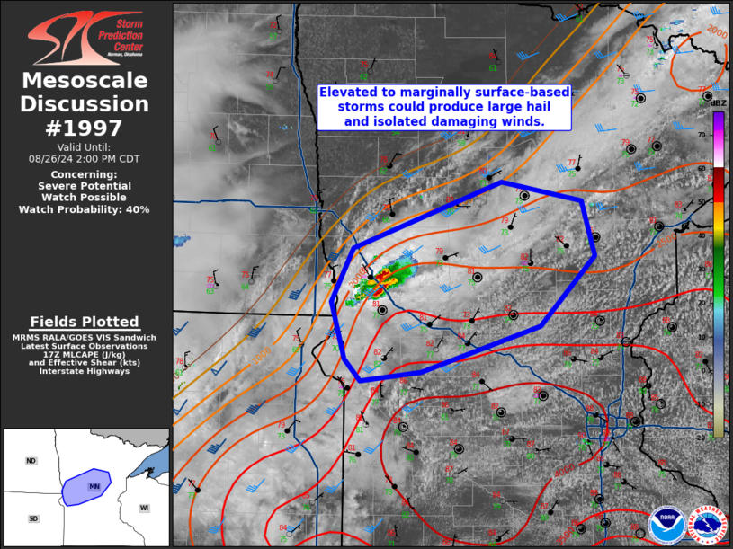
NWS Storm Prediction Center Norman OK
1235 PM CDT Mon Aug 26 2024
Areas affected...Portions of central Minnesota
Concerning...Severe potential...Watch possible
Valid 261735Z - 261900Z
Probability of Watch Issuance...40 percent
SUMMARY...Initial storm development in central Minnesota may be
elevated to marginally surface based and struggle against residual
capping. Should storms mature, large hail and wind damage are
possible. A watch is possible, but this will depend on trends in
convective evolution.
DISCUSSION...Convection has developed in west-central Minnesota,
likely aided by weak warm advection at lower levels. This mornings
soundings from Aberdeen/Minneapolis showed a warm nose within the
850-700 mb layer. It appears that convection is struggling to
intensify/organize with this capping in place. Furthermore,
large-scale ascent is currently weak. Should this activity mature,
large hail and isolated wind damage would be possible.
Short-term guidance is not consistent in how this activity will
evolve, with some suggesting it will weaken in the next few hours
and others showing cold pool development that spurs new convection
farther south where greater buoyancy resides. From a large-scale
perspective, greater ascent/mid-level cooling is not expected until
later in the afternoon, though an MCV moving through eastern South
Dakota could potentially supplement ascent locally earlier. The most
probable scenario is that more robust convection will develop by
mid/late afternoon near an area of surface convergence in central
Minnesota. The need for a watch in the short term is uncertain;
however, trends will continue to be closely monitored this
afternoon.
..Wendt/Guyer.. 08/26/2024
...Please see www.spc.noaa.gov for graphic product...
ATTN...WFO...DLH...MPX...FGF...ABR...
LAT...LON 45449550 45369626 45559646 46069663 46529636 47109448
46939347 46459331 45849401 45449550
|
|
Top/All Mesoscale Discussions/Forecast Products/Home
|
|


 @NWSSPC