|
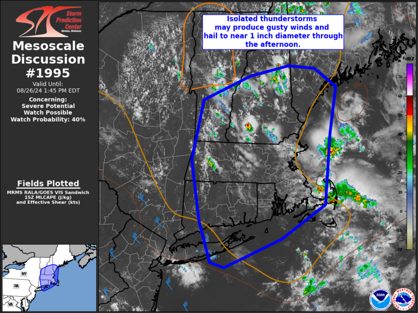
| Mesoscale Discussion 1995 |
|
< Previous MD Next MD >
|
|
   Mesoscale Discussion 1995
   NWS Storm Prediction Center Norman OK
   1051 AM CDT Mon Aug 26 2024

   Areas affected...portions of New England

   Concerning...Severe potential...Watch possible

   Valid 261551Z - 261745Z

   Probability of Watch Issuance...40 percent

   SUMMARY...Isolated thunderstorms may produce gusty winds and hail
   around 1-1.5 inch diameter through the afternoon. Trends are being
   monitored for possible watch issuance.

   DISCUSSION...Thunderstorms are gradually increasing in coverage and
   intensity at midday as strong heating occurs across a seasonally
   moist airmass. The 12z RAOB from ALB indicated modestly steep
   midlevel lapse rates around 6.5-7 C/km amid 30 kt 0-6 km
   northwesterly flow. Cool midlevel temperatures contributing modest
   instability, and elongated/straight hodographs suggest large hail
   will be possible with stronger cells. Effective shear magnitudes
   will be somewhat marginal for longer-lived well-organized updrafts,
   and convection may be somewhat pulse-like. As additional heating
   occurs, steepening low-level lapse rates also may support sporadic
   strong/locally damaging gusts. Convective trends are being monitored
   for possible watch issuance for portions of the MCD area, with
   somewhat greater watch potential focused across southern New England
   this afternoon.

   ..Leitman/Guyer.. 08/26/2024

   ...Please see www.spc.noaa.gov for graphic product...

   ATTN...WFO...GYX...BOX...BTV...OKX...ALY...

   LAT...LON   42417333 43477307 43887195 44077104 44017041 43706991
               42857006 41637019 41037123 40527256 40627289 41347314
               42417333
|
|
Top/All Mesoscale Discussions/Forecast Products/Home
|
|


 @NWSSPC