|
| Mesoscale Discussion 1994 |
|
< Previous MD Next MD >
|
|
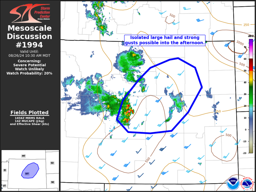
   Mesoscale Discussion 1994
   NWS Storm Prediction Center Norman OK
   0958 AM CDT Mon Aug 26 2024

   Areas affected...portions of central WY

   Concerning...Severe potential...Watch unlikely

   Valid 261458Z - 261630Z

   Probability of Watch Issuance...20 percent

   SUMMARY...Isolated thunderstorms may sporadically produce large hail
   to near 1.25 inch diameter and strong gusts to 65 mph into early
   afternoon across portions of central Wyoming.

   DISCUSSION...Isolated strong to severe thunderstorms have developed
   this morning within strong ascent associated with an upper shortwave
   trough now ejecting east/northeast across western WY. The 12z RAOB
   from RIW showed very steep midlevel lapse rates and cold
   temperatures aloft amid increasing south/southwesterly mid/upper
   level flow. This vertical wind profile will maintain
   elongated/straight hodographs as the system continues to progress
   east/northeast into early afternoon. This environment will remain
   favorable for marginally severe hail over the next few hours. As
   stronger heating occurs with eastward extent, steepening low-level
   lapse rates and only modest boundary layer moisture may foster
   isolated strong gusts as well. Given limited coverage and overall
   marginal nature of the severe risk over the next few hours, a watch
   is not expected.

   ..Leitman/Guyer.. 08/26/2024

   ...Please see www.spc.noaa.gov for graphic product...

   ATTN...WFO...UNR...CYS...RIW...

   LAT...LON   42800862 43360840 43940779 44260736 44500660 44530627
               44270561 43710536 43010589 42500653 42420735 42450818
               42800862
|
|
Top/All Mesoscale Discussions/Forecast Products/Home
|
|


 @NWSSPC