|
| Mesoscale Discussion 1993 |
|
< Previous MD Next MD >
|
|
Mesoscale Discussion 1993
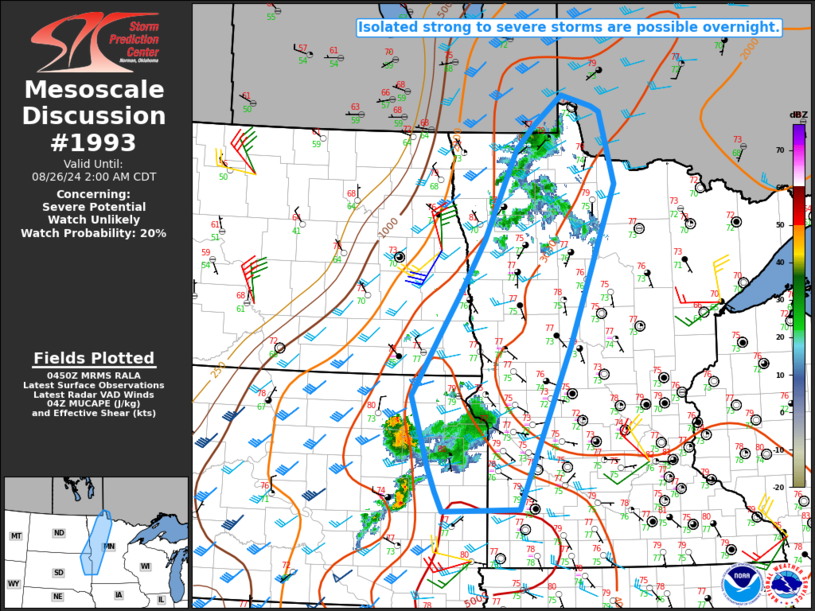
NWS Storm Prediction Center Norman OK
1153 PM CDT Sun Aug 25 2024
Areas affected...Southeast ND into northeast SD and western MN
Concerning...Severe potential...Watch unlikely
Valid 260453Z - 260700Z
Probability of Watch Issuance...20 percent
SUMMARY...Isolated strong to severe storms are possible overnight.
DISCUSSION...Capping and a lack of large-scale ascent has thus far
inhibited storm development along/ahead of a cold front now moving
across eastern ND into northwest MN. While the opportunity for
surface-based development along the front has diminished, modest
ascent and midlevel moistening associated with a weak shortwave
trough moving across ND could support elevated thunderstorm
development later tonight. Strong MUCAPE and sufficient deep-layer
shear will be conditionally favorable for organized convection, and
some threat for isolated hail and damaging wind could evolve if
robust development can occur.
Farther south, an outflow-driven storm cluster across northeast SD
has shown signs of weakening, but may pose a short-term threat of
gusty/damaging winds as it approaches west-central MN and extreme
southeast ND. There will be some potential for elevated convection
to occasionally flare up in the vicinity of this remnant cluster,
though the severe potential from any redevelopment will likely tend
to be relatively isolated.
..Dean/Gleason.. 08/26/2024
...Please see www.spc.noaa.gov for graphic product...
ATTN...WFO...DLH...MPX...FGF...FSD...ABR...
LAT...LON 49269438 48359411 46329494 44239586 44219727 44459739
44769753 45689784 46489729 46989695 47649651 48779594
49099561 49479508 49329452 49269438
|
|
Top/All Mesoscale Discussions/Forecast Products/Home
|
|


 @NWSSPC