|
| Mesoscale Discussion 1991 |
|
< Previous MD Next MD >
|
|
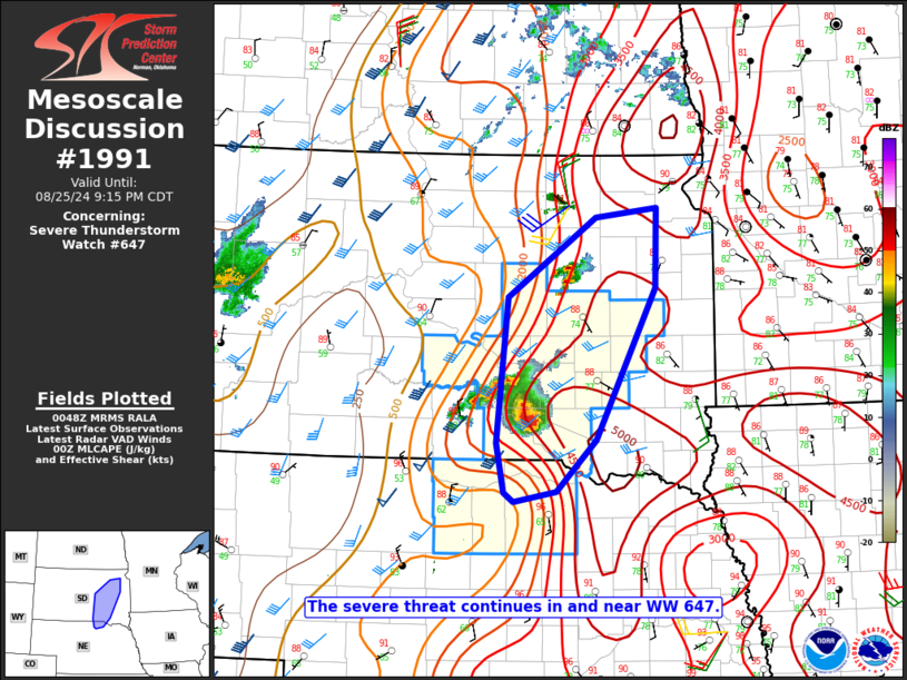
   Mesoscale Discussion 1991
   NWS Storm Prediction Center Norman OK
   0750 PM CDT Sun Aug 25 2024

   Areas affected...Eastern SD into extreme north-central NE

   Concerning...Severe Thunderstorm Watch 647...

   Valid 260050Z - 260215Z

   The severe weather threat for Severe Thunderstorm Watch 647
   continues.

   SUMMARY...The severe threat continues in and near WW 647.

   DISCUSSION...Multiple storm mergers have resulted in the development
   of a supercell cluster across Gregory and Charles Mix Counties in
   SD, with hail up to baseball size reported within the last hour.
   Strong to extreme instability (MLCAPE of 3000-4500 J/kg) and
   sufficient deep-layer shear (as noted on the 00Z ABR sounding) will
   continue to support this cluster in the short-term, with a threat of
   large hail, severe gusts in the 60-80 mph range, and possibly a
   tornado given the presence of modestly enhanced low-level SRH.
   Longevity of this cluster later this evening remains somewhat
   uncertain due to increasing MLCINH, but some severe threat could
   eventually approach the southeast edge of WW 647.

   Other cells have recently developed near the Beadle/Spink county
   border, near the edge of WW 647. These cells could also evolve into
   a supercell or two and pose a threat of hail and localized severe
   gusts this evening, though they may also struggle with increasing
   MLCINH. Local watch expansion may be needed, depending on
   observational trends regarding these cells.

   ..Dean.. 08/26/2024

   ...Please see www.spc.noaa.gov for graphic product...

   ATTN...WFO...FSD...ABR...LBF...

   LAT...LON   43169936 44579921 45339803 45429721 44659724 43189803
               42699857 42599914 42679927 43169936
|
|
Top/All Mesoscale Discussions/Forecast Products/Home
|
|


 @NWSSPC