|
| Mesoscale Discussion 1986 |
|
< Previous MD Next MD >
|
|
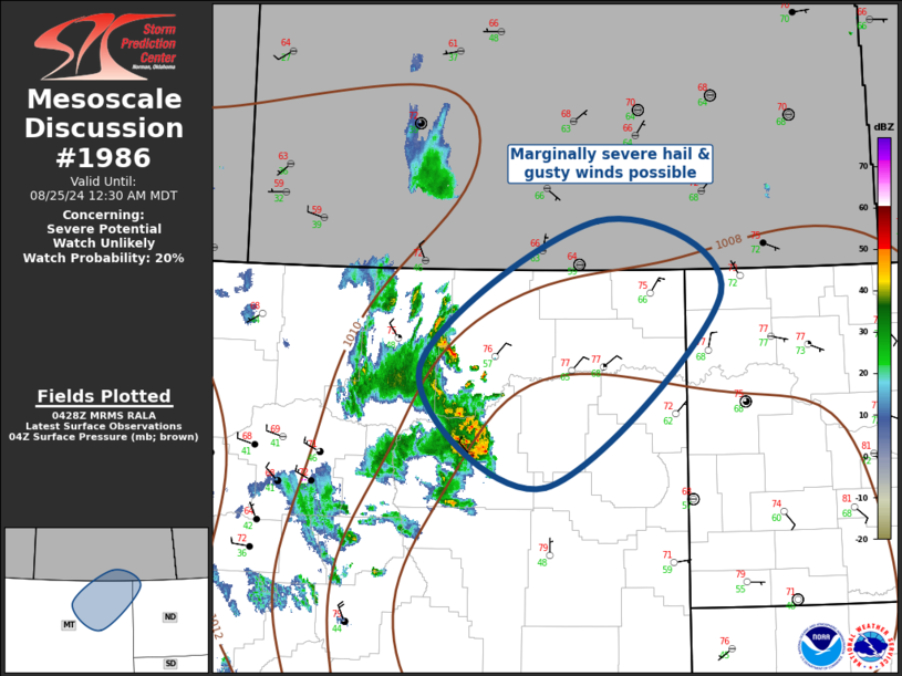
   Mesoscale Discussion 1986
   NWS Storm Prediction Center Norman OK
   1130 PM CDT Sat Aug 24 2024

   Areas affected...Northeast Montana and extreme northwest North
   Dakota

   Concerning...Severe potential...Watch unlikely

   Valid 250430Z - 250630Z

   Probability of Watch Issuance...20 percent

   SUMMARY...Gusty winds and marginally severe hail threat are expected
   with convection into the early morning hours across northeast
   Montana.

   DISCUSSION...Right-entrance region of a mid-level jet over southern
   SK may be partly responsible for recent uptick in elevated
   convection that is spreading into northeast MT. Latest surface data
   suggests a weak low is tracking across southeast MT toward western
   ND. Primary pacific frontal surge is associated with a gradually
   expanding cluster of thunderstorms from southern Phillips to
   northern Rosebud County. Severe wind gust has recently been reported
   at JDN along the leading edge of this activity. Latest HREF guidance
   has a reasonable handle on this scenario and subsequent movement
   should spread across the remainder of northeast MT early this
   morning. Unless multiple supercells develop within this expanding
   cluster, hail production should be limited and generally less than
   one inch. Even so, an isolated severe report or two can not be ruled
   out, and most likely will be a gust approaching 50kt. Given the
   marginality of this convection, current thinking is a severe
   thunderstorm watch is not currently needed.

   ..Darrow/Gleason.. 08/25/2024

   ...Please see www.spc.noaa.gov for graphic product...

   ATTN...WFO...BIS...GGW...

   LAT...LON   48100763 49440522 48780356 47030593 48100763
|
|
Top/All Mesoscale Discussions/Forecast Products/Home
|
|


 @NWSSPC