|
| Mesoscale Discussion 1987 |
|
< Previous MD Next MD >
|
|
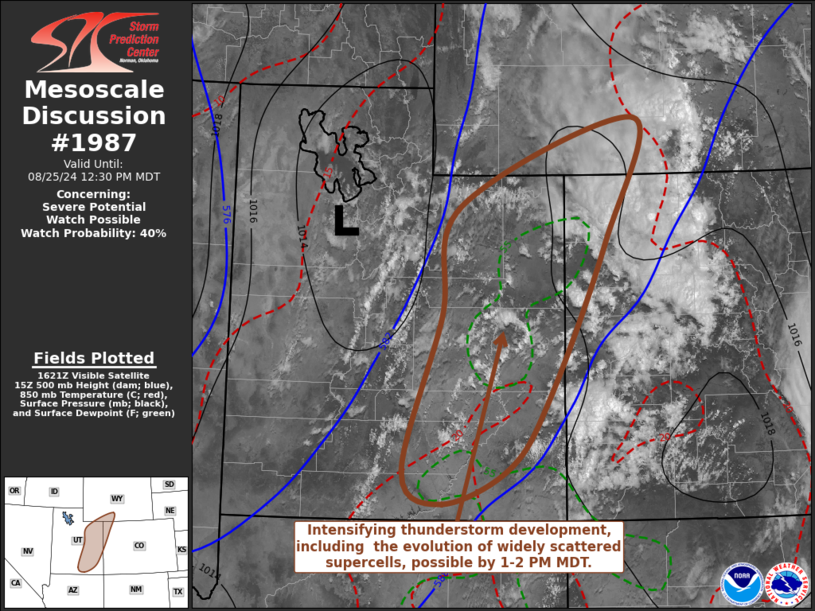
   Mesoscale Discussion 1987
   NWS Storm Prediction Center Norman OK
   1127 AM CDT Sun Aug 25 2024

   Areas affected...parts of eastern Utah...adjacent northwestern
   Colorado and southwestern Wyoming

   Concerning...Severe potential...Watch possible

   Valid 251627Z - 251830Z

   Probability of Watch Issuance...40 percent

   SUMMARY...Intensifying renewed thunderstorm development is possible
   across much of eastern Utah by 1-2 PM MDT.  Widely scattered
   stronger storms may pose a risk for severe hail and wind while
   spreading northeastward and eastward through late afternoon.  While
   it is still not yet certain that a severe weather watch will be
   needed, trends are being monitored for this possibility.

   DISCUSSION...Downstream of a seasonably vigorous short wave trough
   slowly progressing east-northeastward through the Great Basin, a
   narrow band of large-scale ascent continues to gradually spread east
   of the Wasatch.  This is in the wake of initial low-level warm
   advection driven convection now spreading spreading northeastward
   through the Colorado and adjacent Wyoming Rockies, with insolation
   across a relatively moist boundary layer over much of eastern Utah
   contributing to increasing destabilization.

   Through 18-20Z, models suggest that mixed-layer CAPE may increase to
   500-1000 J/kg, coincident with further strengthening of south to
   southwesterly mid/upper wind fields (including 30-70+ kt in the
   700-300 mb layer).  As new thunderstorm development begins to
   initiate, it appears that this regime will become potentially
   conducive to evolution of isolated supercells.  In addition to
   posing a risk for large hail, stronger storms may become capable of
   producing locally severe wind gusts, particularly as they spread
   across the more strongly heated and deeply mixed lower elevations
   through late afternoon.

   ..Kerr/Guyer.. 08/25/2024

   ...Please see www.spc.noaa.gov for graphic product...

   ATTN...WFO...RIW...GJT...SLC...

   LAT...LON   40631059 41650798 40220842 38420926 37600986 37181085
               37551144 39331088 40631059
|
|
Top/All Mesoscale Discussions/Forecast Products/Home
|
|


 @NWSSPC