Mesoscale Discussion 1985
NWS Storm Prediction Center Norman OK
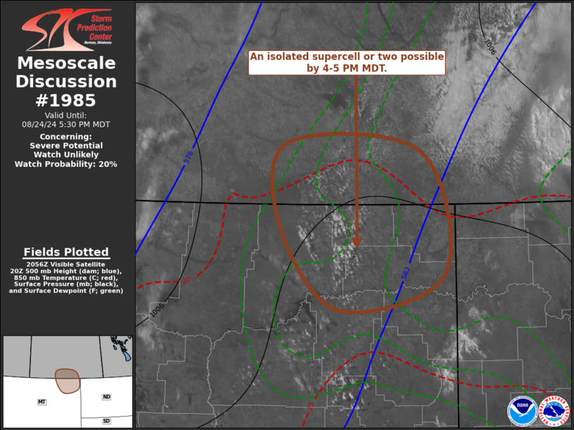
0400 PM CDT Sat Aug 24 2024
Areas affected...parts of northeastern Montana
Concerning...Severe potential...Watch unlikely
Valid 242100Z - 242330Z
Probability of Watch Issuance...20 percent
SUMMARY...Thunderstorm activity may begin to initiate, with the
evolution of an isolated supercell possible, by 4-5 PM MDT. This
may pose a risk for large hail, locally damaging wind gusts, and
perhaps some potential for a brief tornado.
DISCUSSION...Low-level convergence appears to be locally
strengthening within weak surface troughing near the Wolf Point
vicinity, where surface dew points remain in the lower/mid 60s F, as
temperatures warm into the 90s F. Inhibition is gradually eroding
with continuing insolation, and this may be aided by weak mid-level
cooling through late afternoon, downstream of a mid-level
perturbation progressing across and northeast of the Canadian
Rockies.
Initial attempts at deepening convective development appear slowly
underway, in the presence of thermodynamic profiles already
characterized by steep lower/mid-tropospheric lapse rates and CAPE
in excess of 2000 J/kg. Beneath 35-60+ kt south-southwesterly flow
in the 500-300 mb layer, deep-layer shear is already strong and
conditionally supportive of supercells.
Although the strength of mid/upper forcing for ascent remains a bit
unclear, the High Resolution Rapid Refresh and Rapid Refresh, in
particular, suggest that at least isolated thunderstorms may
initiate as early as 22-23Z. Once this occurs, intensification may
be fairly rapid, with storms becoming capable of producing large
hail, locally damaging gusts gusts, and perhaps some risk for a
brief tornado, despite generally small/linear low-level hodographs.
..Kerr/Guyer.. 08/24/2024
...Please see www.spc.noaa.gov for graphic product...
ATTN...WFO...GGW...
LAT...LON 49550459 48250422 47870592 48790686 49660673 49550459
|


 @NWSSPC