|
| Mesoscale Discussion 1981 |
|
< Previous MD Next MD >
|
|
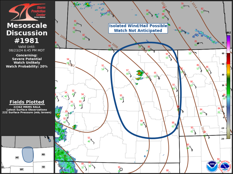
   Mesoscale Discussion 1981
   NWS Storm Prediction Center Norman OK
   0539 PM CDT Fri Aug 23 2024

   Areas affected...Eastern Montana

   Concerning...Severe potential...Watch unlikely

   Valid 232239Z - 240045Z

   Probability of Watch Issuance...20 percent

   SUMMARY...Isolated threat for wind/hail will be noted with
   convection this evening. Watch is not currently anticipated.

   DISCUSSION...Mid-level heights are being suppressed a bit over
   central/eastern MT along the eastern influence of a short-wave
   trough that is ejecting north across the northern Rockies. While
   large-scale influence of this feature will likely remain focused
   across western MT, strong boundary-layer heating has contributed to
   steep 0-3km lapse rates as temperature are now well into the mid
   90s. Convective temperature have been breached, and negligible CINH
   is supported by thickening boundary-layer cu field, and isolated
   thunderstorms between GGW-OLF. This clustering is occurring within a
   zone of favorable low-level confluence, and along an instability
   axis where MLCAPE values are in excess of 2000 J/kg. There is some
   concern a few robust updrafts will evolve across eastern MT over the
   next few hours as surface-6km bulk shear is more than adequate for
   sustaining organized updrafts; however, it's not entirely clear how
   many storms will evolve. Another concern is any storms that linger
   beyond sunset will eventually be aided by a strengthening LLJ. Will
   continue to monitor this region, but at this time a watch is not
   currently anticipated.

   ..Darrow/Gleason.. 08/23/2024

   ...Please see www.spc.noaa.gov for graphic product...

   ATTN...WFO...BYZ...GGW...

   LAT...LON   49010432 46200421 46210675 48800743 49010432
|
|
Top/All Mesoscale Discussions/Forecast Products/Home
|
|


 @NWSSPC