|
| Mesoscale Discussion 1980 |
|
< Previous MD Next MD >
|
|
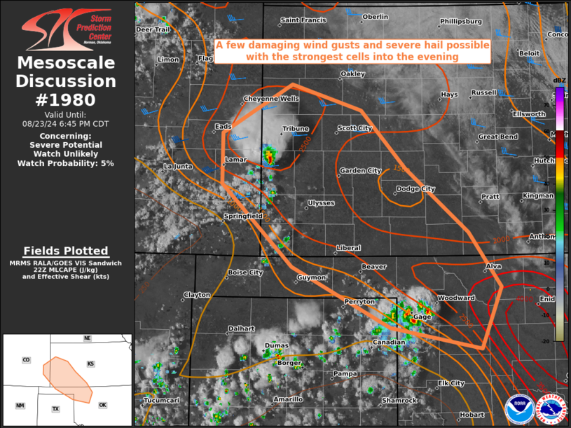
   Mesoscale Discussion 1980
   NWS Storm Prediction Center Norman OK
   0515 PM CDT Fri Aug 23 2024

   Areas affected...Western Kansas...far Eastern Colorado...the OK/TX
   Panhandles and Northwest Oklahoma

   Concerning...Severe potential...Watch unlikely

   Valid 232215Z - 232345Z

   Probability of Watch Issuance...5 percent

   SUMMARY...A few damaging wind gusts and severe hail possible with
   the strongest cells into the evening.

   DISCUSSION...Visible satellite shows an uptick in convective
   development across the region as peak heating has allowed surface
   temperatures to rise into the upper 90s and low 100s F, eclipsing
   convective temperatures. Southeasterly low-level flow has ushered in
   ample moisture, with surface dew point temperatures in the mid 60s
   F. This combination is yielding MLCAPE of 1500-2000 J/kg in areas
   downstream of northeastward-moving developing convection. Marginally
   enhanced west-southwesterly mid-level flow is resulting in upwards
   of 30-35 kt of effective bulk shear that increases with northward
   extent.

   The ongoing convective activity is expected to continue through the
   evening. Steep low-level lapse rates should promote a few damaging
   wind gusts with the strongest cells, along with some severe hail.
   However, convective inhibition increases with eastward extent. This
   along with a gradual loss of peak heating should limit storm
   organization and severe coverage, though convective trends will be
   monitored.

   ..Karstens/Gleason.. 08/23/2024

   ...Please see www.spc.noaa.gov for graphic product...

   ATTN...WFO...OUN...DDC...GLD...AMA...PUB...

   LAT...LON   37850262 38460262 39060157 38740052 38059986 37289892
               36619843 35889873 36140010 36860156 37850262
|
|
Top/All Mesoscale Discussions/Forecast Products/Home
|
|


 @NWSSPC