|
| Mesoscale Discussion 1982 |
|
< Previous MD Next MD >
|
|
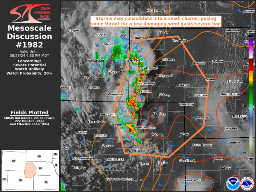
   Mesoscale Discussion 1982
   NWS Storm Prediction Center Norman OK
   0553 PM CDT Fri Aug 23 2024

   Areas affected...Portions of northeast Colorado...far southeast
   Wyoming...and western Nebraska

   Concerning...Severe potential...Watch unlikely

   Valid 232253Z - 240030Z

   Probability of Watch Issuance...20 percent

   SUMMARY...Storms may consolidate into a small cluster, posing a some
   threat for a few damaging wind gusts. Watch issuance not anticipated
   at this time, though convective trends will be monitored.

   DISCUSSION...Convection initiating off the high terrain areas of
   north-central Colorado and southeastern Wyoming has drifted eastward
   amid marginally enhanced westerly mid-level flow. This activity is
   increasing in intensity as it encounters richer low-level moisture,
   characterized by surface dew point temperatures in the low to mid
   60s F within easterly upslope flow and greater instability (MLCAPE
   approaching 2000 J/kg) amid increasing surface temperatures.

   Storm intensity is expected to continue increasing in the short term
   as the activity moves into more favorable airmass. The combination
   of speed/directional shear is yielding effective bulk shear near 35
   kt across the region, which may help to promote at least transient
   storm organization. Recent HRRR runs suggest a cluster may emerge
   over the next hour or so, which could pose at least a brief damaging
   wind/hail threat over northeast Colorado and the Nebraska Panhandle
   in the short term. However, increasing convective inhibition into
   the evening is expected limit the eastward extent of the severe
   threat, as supported by recent HRRR runs.  For now, watch issuance
   is unlikely but convective trends will be monitored.

   ..Karstens/Gleason.. 08/23/2024

   ...Please see www.spc.noaa.gov for graphic product...

   ATTN...WFO...LBF...GLD...BOU...CYS...

   LAT...LON   39560340 39600417 40760458 42660391 42780226 41510116
               40310139 39500263 39560340
|
|
Top/All Mesoscale Discussions/Forecast Products/Home
|
|


 @NWSSPC