|
| Mesoscale Discussion 1964 |
|
< Previous MD Next MD >
|
|
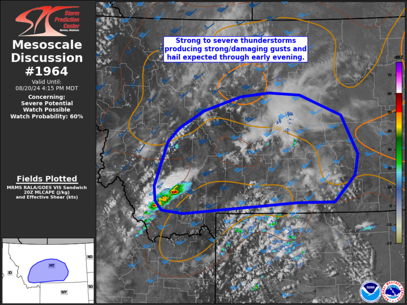
   Mesoscale Discussion 1964
   NWS Storm Prediction Center Norman OK
   0311 PM CDT Tue Aug 20 2024

   Areas affected...southwest into central MT

   Concerning...Severe potential...Watch possible

   Valid 202011Z - 202215Z

   Probability of Watch Issuance...60 percent

   SUMMARY...Isolated to widely scattered thunderstorms could produce
   strong/damaging gusts and isolated hail into early evening across
   parts of southeast into central Montana. Area is being monitored for
   possible severe thunderstorm watch issuance.

   DISCUSSION...Isolated thunderstorms have developed this afternoon
   over the higher terrain of southwest Montana. This area has quickly
   warmed into the 80s F as earlier cloud cover has shifted northeast.
   Additional convection is expected to develop further east near the
   Beartooth/Absarokas over the next couple of hours. Collectively this
   convection will spread northeast into this evening.

   Modest instability, mainly supported by steep midlevel lapse
   rates/cool temps aloft, and effective shear magnitudes greater than
   35 kt will support organized/robust updrafts. Forecast hodographs
   along with regional VWP data also indicate shear favorable for
   supercells. Given high-based storms and steepening low-level lapse
   rates, strong/damaging gusts are possible with this activity as it
   becomes better organized with time and northeastward extent into the
   high Plains. A few instances of hail up to 1.25 inch diameter is
   also possible. A severe thunderstorm watch may be needed this
   afternoon.

   ..Leitman/Hart.. 08/20/2024

   ...Please see www.spc.noaa.gov for graphic product...

   ATTN...WFO...BYZ...GGW...TFX...MSO...

   LAT...LON   45531289 46451251 46751218 47121145 47421034 47500949
               47450855 47020732 46200683 45770694 45210755 45210863
               44971202 45041265 45231284 45531289
|
|
Top/All Mesoscale Discussions/Forecast Products/Home
|
|


 @NWSSPC