|
| Mesoscale Discussion 1965 |
|
< Previous MD Next MD >
|
|
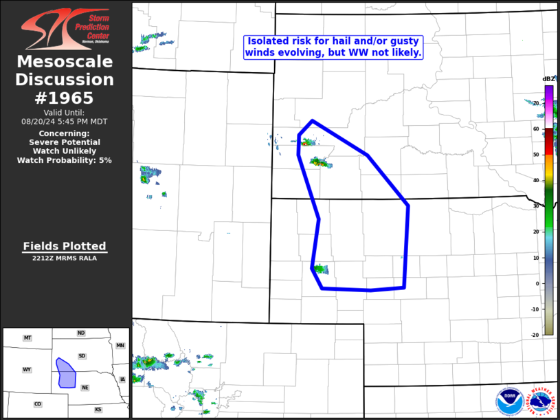
   Mesoscale Discussion 1965
   NWS Storm Prediction Center Norman OK
   0515 PM CDT Tue Aug 20 2024

   Areas affected...southwestern South Dakota to the Nebraska Panhandle
   vicinity

   Concerning...Severe potential...Watch unlikely

   Valid 202215Z - 202345Z

   Probability of Watch Issuance...5 percent

   SUMMARY...Isolated storms from the Black Hills area south into the
   Nebraska Panhandle are evolving, one or two of which may briefly be
   capable of producing hail and/or strong wind gusts.  Coverage of the
   risk should remain well below that needed to warrant WW
   consideration.

   DISCUSSION...Latest radar loop shows very isolated storm development
   over the Black Hills vicinity (in a northeasterly/upslope low-level
   flow regime), and southward into the Nebraska Panhandle region in
   the vicinity of a surface low.  The storms are initiating in an
   environment that has heated/destabilized modestly, on the western
   fringe the axis of greater low-level moisture/mixed-layer CAPE (1500
   to 2500 J/kg north and east of the Black Hills, and southward into
   western Nebraska).

   The wind field across the area is backing with height, indicative of
   cold advection north/northwest of the surface low.  Still, the
   magnitude of the flow is sufficient to support some updraft
   organization -- as observed within the Custer County, SD storm over
   the past hour.  Though overall severe risk should remain low
   overall, the potential for one or two storms to approach or slightly
   exceed severe levels does exist, for the next couple of hours.

   ..Goss/Guyer.. 08/20/2024

   ...Please see www.spc.noaa.gov for graphic product...

   ATTN...WFO...LBF...UNR...CYS...

   LAT...LON   41570293 41890316 42680301 43700348 44010347 44240317
               43700196 42880108 41570118 41530189 41570293
|
|
Top/All Mesoscale Discussions/Forecast Products/Home
|
|


 @NWSSPC