|
| Mesoscale Discussion 1955 |
|
< Previous MD Next MD >
|

|
   Mesoscale Discussion 1955
   NWS Storm Prediction Center Norman OK
   0125 PM CDT Mon Aug 19 2024

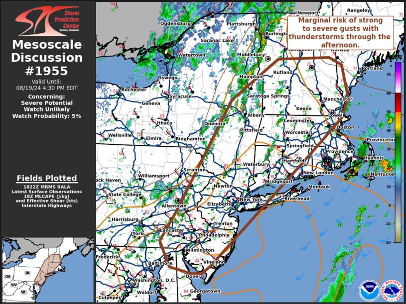
   Areas affected...portions of New England

   Concerning...Severe potential...Watch unlikely

   Valid 191825Z - 192030Z

   Probability of Watch Issuance...5 percent

   SUMMARY...Scattered thunderstorm activity may produce strong to
   severe gusts through the afternoon.

   DISCUSSION...Thunderstorm activity ongoing along and ahead of a cold
   front across portions of New England has shown an uptick in coverage
   over the last hour. Much of the region has been under mid-level
   cloud cover through the morning. However, a few breaks in the clouds
   have allowed temperatures to warm into the 80s with MLCAPE around
   500-1000 J/kg. Deep layer shear for organization remains mostly
   offshore, with poor low to mid-level lapse rates. A few clusters of
   stronger storms may produce strong to severe gusts at times.
   Overall, the lack of support for organization of a more widespread
   severe threat will keep this threat localized precluding the need to
   for a watch.

   ..Thornton/Hart.. 08/19/2024

   ...Please see www.spc.noaa.gov for graphic product...

   ATTN...WFO...GYX...BOX...BTV...OKX...ALY...PHI...BGM...CTP...
   LWX...

   LAT...LON   39177503 39167532 39297597 39877626 40557581 43067419
               43987278 43997120 43827082 43107066 42647086 41797190
               39317479 39177503
|
|
Top/All Mesoscale Discussions/Forecast Products/Home
|
|


