|
| Mesoscale Discussion 1956 |
|
< Previous MD Next MD >
|
|
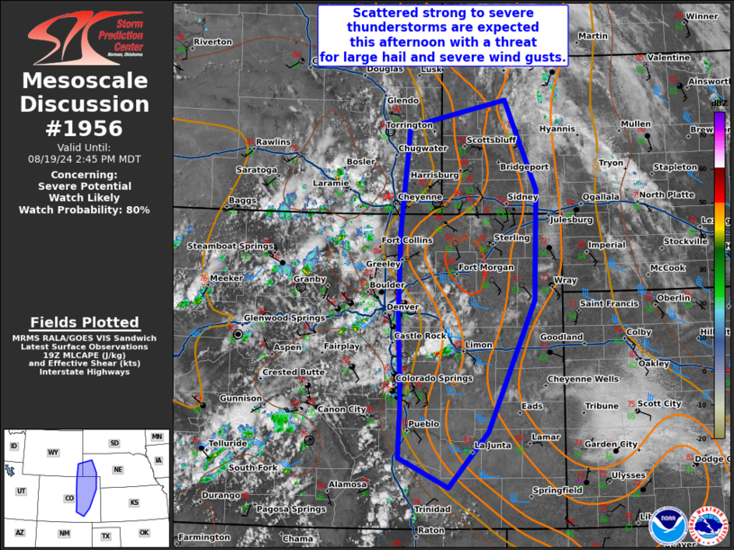
   Mesoscale Discussion 1956
   NWS Storm Prediction Center Norman OK
   0219 PM CDT Mon Aug 19 2024

   Areas affected...southeast Wyoming...parts of the Nebraska
   Panhandle...and much of eastern Colorado

   Concerning...Severe potential...Watch likely

   Valid 191919Z - 192045Z

   Probability of Watch Issuance...80 percent

   SUMMARY...Scattered strong to severe thunderstorms are expected this
   afternoon in the central High Plains with a threat for large hail
   and severe wind gusts.

   DISCUSSION...Moderate destabilization has occurred across eastern
   Colorado amid moist upslope flow (mid 60s dewpoints) and
   temperatures in the 80s. SPC mesoanalysis has indicated inhibition
   is decreasing along the Front Range. At least some inhibition is
   expected to remain across the Plains this afternoon which will
   likely limit storm initiation, however, scattered thunderstorm
   development is expected along the higher terrain which should
   intensify as it moves east into the more unstable airmass across the
   Plains this afternoon and evening. Mid-upper level flow of 30 to 40
   knots combined with easterly flow at the surface will provide ample
   wind shear for some storm organization including the potential for a
   few supercells Despite the relatively warm temperatures aloft
   beneath the upper-ridge axis, steep lapse rates and the moderate
   shear should support some hail threat, especially early in the storm
   lifecycle when storm mode is more discrete. Later this afternoon and
   especially into the evening, expect the threat to transition to
   severe wind gusts with one or more clusters of storms which may
   develop out of the afternoon/early evening convection.

   ..Bentley/Hart.. 08/19/2024

   ...Please see www.spc.noaa.gov for graphic product...

   ATTN...WFO...LBF...GLD...PUB...BOU...CYS...

   LAT...LON   37890474 38540471 38970472 39720475 40790473 42110458
               42450298 41310246 39900251 38220328 37520393 37890474
|
|
Top/All Mesoscale Discussions/Forecast Products/Home
|
|


 @NWSSPC