|
| Mesoscale Discussion 1948 |
|
< Previous MD Next MD >
|
|
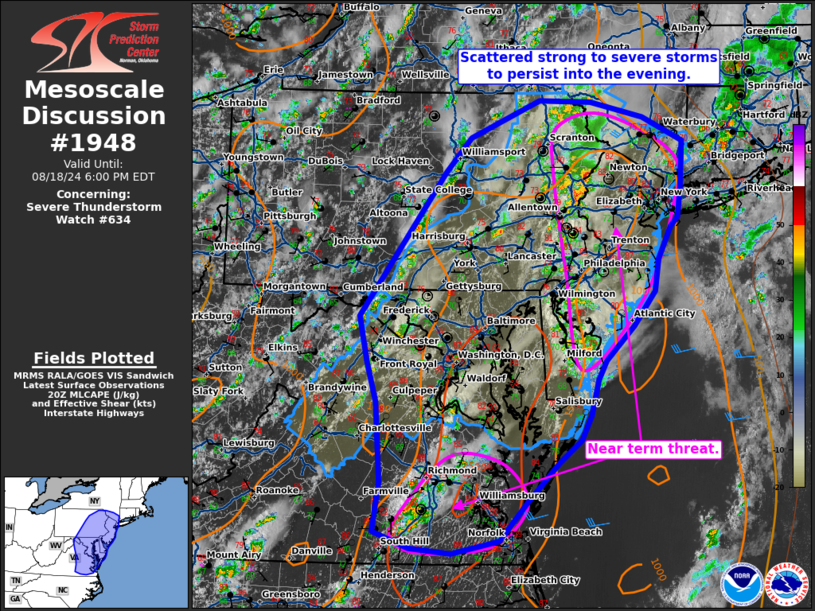
   Mesoscale Discussion 1948
   NWS Storm Prediction Center Norman OK
   0330 PM CDT Sun Aug 18 2024

   Areas affected...portions of the mid-Atlantic

   Concerning...Severe Thunderstorm Watch 634...

   Valid 182030Z - 182200Z

   The severe weather threat for Severe Thunderstorm Watch 634
   continues.

   SUMMARY...Scattered strong to severe storms are expected to persist
   into the evening.

   DISCUSSION...Scattered thunderstorms have developed within the
   unstable airmass across eastern Pennsylvania and Delaware and are
   moving into New Jersey and southwest New York. These storms have
   been mostly multicellular in nature with a few reports of damaging
   winds and large hail. These storms may be somewhat more productive
   in the next 1 to 2 hours as they move into a hotter airmass across
   New Jersey which was not impacted by morning clouds.

   The airmass continues to destabilize to the lee of the Appalachians
   where temperatures have warmed into the mid to upper 80s. Short term
   guidance (18Z HRRR and hires NAM) continues to suggest an additional
   round of thunderstorms may develop this evening and move into the
   I-95 corridor near sunset.

   ..Bentley.. 08/18/2024

   ...Please see www.spc.noaa.gov for graphic product...

   ATTN...WFO...OKX...ALY...PHI...BGM...AKQ...CTP...LWX...

   LAT...LON   41087720 41477682 41907578 41897500 41707421 41427361
               40887364 40557369 40437380 40077400 39707406 39297437
               38907480 38677491 38267503 37987518 37717550 37257599
               36817638 36667709 36727769 36917822 37487813 38427820
               38877835 39407847 41087720
|
|
Top/All Mesoscale Discussions/Forecast Products/Home
|
|


 @NWSSPC