|
| Mesoscale Discussion 1949 |
|
< Previous MD Next MD >
|
|
Mesoscale Discussion 1949
NWS Storm Prediction Center Norman OK
0519 PM CDT Sun Aug 18 2024
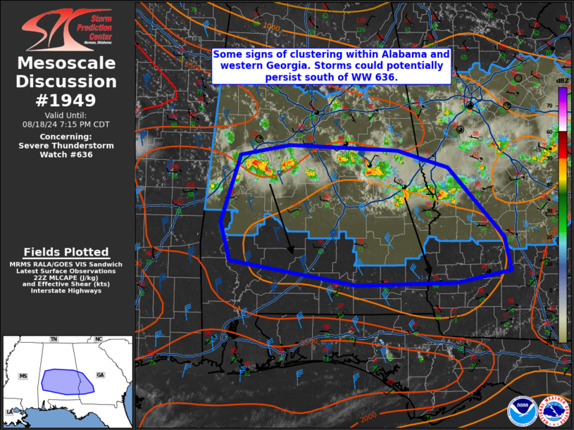
Areas affected...Southeast Alabama into southwest Georgia
Concerning...Severe Thunderstorm Watch 636...
Valid 182219Z - 190015Z
The severe weather threat for Severe Thunderstorm Watch 636
continues.
SUMMARY...Two clusters of storms will likely continue southward late
this afternoon. Damaging winds and marginally severe hail will
remain possible. There is some potential for a downstream watch
depending on convective trends.
DISCUSSION...The most organized convection in WW 636 is moving
southward along the GA/AL border. These storms have so far remained
discrete and produced 1-1.75 inch hail and wind gusts of 36-50 kts
recently. Farther west, in west-central Alabama, another cluster of
storms is also moving south. These storms are being supported by
lift within the base of a mid-level trough. Effective shear is 30-50
kts (stronger to the west) and will continue to support organized
storms. Low-level shear, however, is weaker and temperature-dewpoint
spreads are near 30 F which is leading to outflow moving out ahead
of convection (per KMXX radar imagery). There is some potential for
this activity to persist south of WW 636 into portions of southern
Alabama and southwest Georgia. Damaging wind gusts and marginally
severe hail will remain possible. An additional watch may need to be
considered depending on convective trends over the next 1-2 hours.
..Wendt/Guyer.. 08/18/2024
...Please see www.spc.noaa.gov for graphic product...
ATTN...WFO...FFC...TAE...BMX...MOB...
LAT...LON 31538384 31388464 31368614 31668804 32168818 33018788
33148714 33088552 32868477 31978394 31538384
|
|
Top/All Mesoscale Discussions/Forecast Products/Home
|
|


 @NWSSPC