|
| Mesoscale Discussion 1943 |
|
< Previous MD Next MD >
|
|
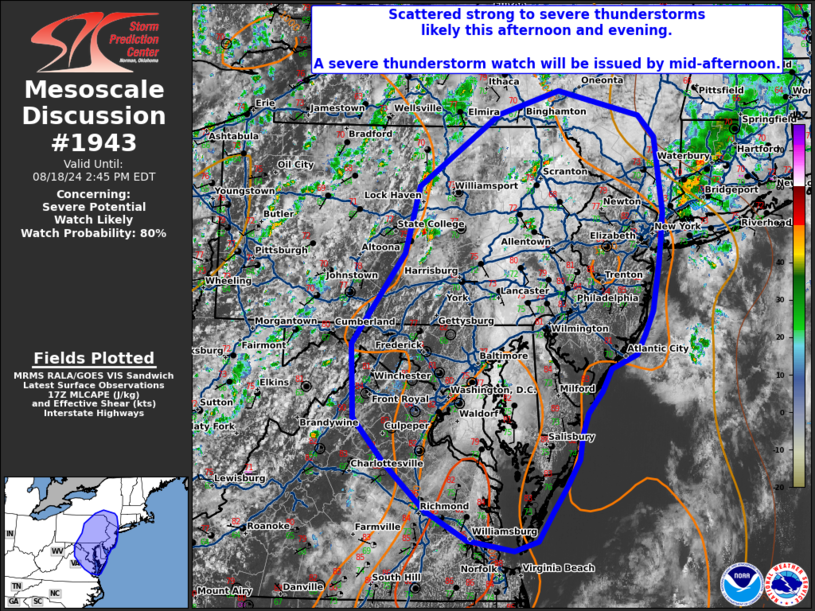
   Mesoscale Discussion 1943
   NWS Storm Prediction Center Norman OK
   1209 PM CDT Sun Aug 18 2024

   Areas affected...southeast New York...New Jersey...eastern
   Pennsylvania...Maryland...and northern Virginia.

   Concerning...Severe potential...Watch likely

   Valid 181709Z - 181845Z

   Probability of Watch Issuance...80 percent

   SUMMARY...Strong to severe thunderstorms are likely this afternoon
   and evening. A severe thunderstorm watch will be issued by
   mid-afternoon.

   DISCUSSION...Thunderstorms have started to develop across the
   Appalachians from central Pennsylvania into southern New York as
   cold-air advection aloft overspread the region. Farther east, some
   inhibition remains across eastern Pennsylvania amid broken
   cloudcover. However, this stratus deck has started to erode and
   should allow for significant surface heating over the next 1 to 2
   hours. Under the influence of weak height falls and cyclonic flow
   aloft, expect scattered thunderstorm development within the uncapped
   environment from eastern Pennsylvania to eastern Virginia. 20 to 25
   knots of effective shear (per RAP forecast soundings) will support
   some multicell organization with a primary threat from downbursts.
   An additional round of storms is possible this afternoon/evening as
   storms which develop over the mountains move into the lower
   elevations with some congealing into one or more linear segments
   possible.

   ..Bentley/Hart.. 08/18/2024

   ...Please see www.spc.noaa.gov for graphic product...

   ATTN...WFO...OKX...ALY...PHI...BGM...AKQ...CTP...LWX...

   LAT...LON   40547769 41317749 42137628 42417538 42127417 41867392
               40997382 40427389 39877399 39617411 39367423 39217462
               38947475 38707496 38437505 38177509 37837529 37577548
               37227571 37127605 37247675 37577737 38117797 38647843
               39487847 40547769
|
|
Top/All Mesoscale Discussions/Forecast Products/Home
|
|


 @NWSSPC