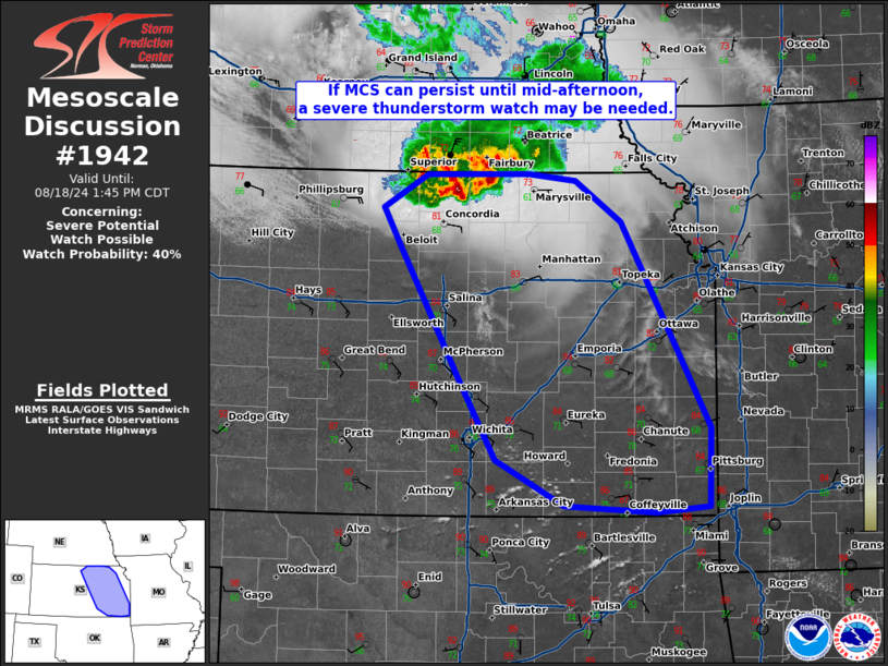
   Mesoscale Discussion 1942
   NWS Storm Prediction Center Norman OK
   1145 AM CDT Sun Aug 18 2024

   Areas affected...eastern Kansas

   Concerning...Severe potential...Watch possible

   Valid 181645Z - 181845Z

   Probability of Watch Issuance...40 percent

   SUMMARY...If a MCS, currently moving out of southeast Nebraska can
   persist until mid-afternoon, a severe thunderstorm watch may be
   needed.

   DISCUSSION...An MCS which developed within a zone of isentropic
   ascent across northern Nebraska last night has persisted and now has
   a well-established cold-pool. Over the last hour, deeper cores and
   cooling cloud tops have been evident on satellite as this cluster of
   storms moves across southeast Nebraska. Despite all 12Z CAM guidance
   suggesting the demise of this cluster by mid-day, current
   radar/satellite trends would suggest it may persist for awhile.
   Strong inhibition remains ahead of this activity currently, but if
   the convection can maintain for another ~2 hours, it may be able to
   transition to surface based as additional heating erodes downstream
   inhibition. If this does occur, moderate instability, steep
   mid-level lapse rates, and 40+ knots of effective shear would
   support a bowing line segment with the potential for 75+ mph wind
   gusts.

   Convective trends will be monitored and if an organized bowing
   cluster of storms seems imminent, a severe thunderstorm watch will
   be issued.

   ..Bentley/Hart.. 08/18/2024

   ...Please see www.spc.noaa.gov for graphic product...

   ATTN...WFO...SGF...EAX...TOP...ICT...GID...

   LAT...LON   39369813 39699832 39989783 39999670 39939616 39579566
               37779467 37089470 37029528 37099630 37499705 38199747
               39369813
|


 @NWSSPC