|
| Mesoscale Discussion 1929 |
|
< Previous MD Next MD >
|
|
Mesoscale Discussion 1929
NWS Storm Prediction Center Norman OK
0122 AM CDT Sat Aug 17 2024
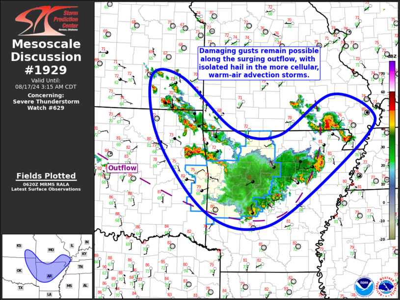
Areas affected...Far Southeast KS...Northeast OK...Northern/Central
AR...Far Southeast MO/MO Bootheel
Concerning...Severe Thunderstorm Watch 629...
Valid 170622Z - 170815Z
The severe weather threat for Severe Thunderstorm Watch 629
continues.
SUMMARY...A few damaging gusts remain possible along the outflow
pushing south across central Arkansas. Isolated hail is also
possible from northeast Oklahoma into far southeast Kansas, and
southeast Missouri into the Missouri Bootheel.
DISCUSSION...Surface analysis reveals an extensive outflow boundary
extending from northwest OK southwestward into central AR and then
back northeastward into northeast AR and southeast MO. Convective
cluster responsible for this outflow continues to progress
southeastward across northern and central AR, with the outflow now
notably ahead of the deep convection. This displacement between the
deep convection and the outflow should persist, and perhaps even
increase, over the next few hours with the overall
intensity/organization of the convective line expected to decrease.
Farther northwest, warm-air advection atop the outflow has resulted
in more cellular development across northeast OK and southeast KS.
Moderate elevated buoyancy (i.e. MUCAPE from around 2000-2500 J/kg)
and moderate vertical shear (i.e. effective bulk shear around 30 to
35 kt) is supporting strong to occasionally severe storms within
this warm-air advection regime. Overall storm coverage is likely
near a maximum now, with isolated hail possible for the next hour or
two.
Lastly, a few storms have quickly intensified across far southeast
MO/MO Bootheel over the past hour, amid modest warm-air advection
near the outflow. Buoyancy is less in this region than areas south
and west, but bulk shear is slightly stronger. As a result, some
isolated hail is possible here for the next hour or two as well.
..Mosier.. 08/17/2024
...Please see www.spc.noaa.gov for graphic product...
ATTN...WFO...PAH...MEG...LSX...LZK...SGF...SHV...TSA...ICT...
LAT...LON 36579611 37869621 37799525 36539366 36389229 37379067
36948942 36268968 34509192 34079313 34339426 35219525
36579611
|
|
Top/All Mesoscale Discussions/Forecast Products/Home
|
|


 @NWSSPC