|
| Mesoscale Discussion 1926 |
|
< Previous MD Next MD >
|

|
   Mesoscale Discussion 1926
   NWS Storm Prediction Center Norman OK
   0845 PM CDT Fri Aug 16 2024

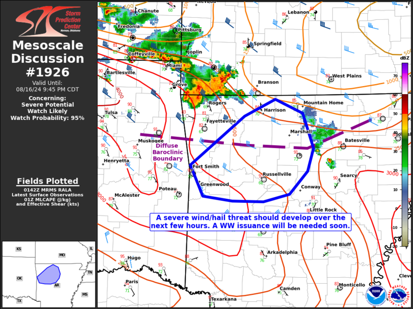
   Areas affected...portions of northwestern Arkansas

   Concerning...Severe potential...Watch likely

   Valid 170145Z - 170245Z

   Probability of Watch Issuance...95 percent

   SUMMARY...The severe threat is increasing across portions of
   northwestern AR. Severe gusts are the main threat, though a few
   instances of large hail are also possible. A WW will be needed soon
   to address the impending severe threat.

   DISCUSSION...A robust multicellular cluster (perhaps with embedded
   transient supercells) continues to rapidly propagate to the
   southeast. Multiple instances of 70-80 mph gusts and wind damage
   have been reported with this cluster, and MRMS MESH suggests that at
   least some marginally severe hail may be falling in the stronger
   storm cores. Preceding these storms is a thermodynamic airmass
   characterized by 2000-3000 J/kg MLCAPE amid only slowly increasing
   MLCINH. Effective bulk shear values are likely exceeding 30 kts per
   00Z mesoanalysis, which is sufficient for continued storm
   organization and intensity given the aforementioned buoyancy. Though
   MLCINH should ultimately tame severe potential later tonight, at
   least some concentrated severe wind/hail threat may still
   materialize over the next couple of hours. A WW issuance will be
   needed soon to address the near-term severe threat.

   ..Squitieri/Edwards.. 08/17/2024

   ...Please see www.spc.noaa.gov for graphic product...

   ATTN...WFO...LZK...TSA...

   LAT...LON   35459441 36189344 36449288 36229238 35719219 35369230
               35039262 34929309 34939366 34999419 35459441
|
|
Top/All Mesoscale Discussions/Forecast Products/Home
|
|


