|
| Mesoscale Discussion 1894 |
|
< Previous MD Next MD >
|

|
   Mesoscale Discussion 1894
   NWS Storm Prediction Center Norman OK
   0448 PM CDT Tue Aug 13 2024

   Areas affected...Eastern Idaho...Western Wyoming...Northern Utah

   Concerning...Severe potential...Watch unlikely

   Valid 132148Z - 140015Z

   Probability of Watch Issuance...5 percent

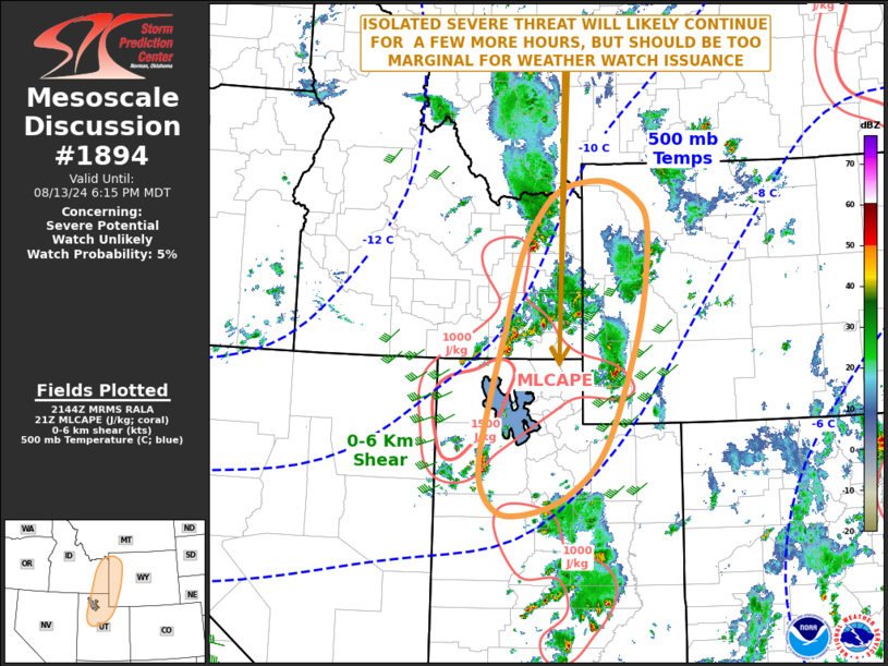
   SUMMARY...An isolated severe threat will likely continue for a few
   more hours. Hail and gusty winds will be the primary threats. The
   severe threats should remain too marginal for weather watch issuance
   is not expected.

   DISCUSSION...The latest water-vapor imagery and 500 mb RAP analysis
   suggest that a shortwave trough is moving through the northern
   Rockies. Lift associated with this feature, is supporting scattered
   thunderstorm development near a pocket of moderate instability from
   northern Utah into eastern Idaho. MLCAPE within this area is
   estimated by the RAP to be in the 1000 to 1500 J/kg range. Mid-level
   lapse rates are also steep. In addition, the latest WSR-88D at
   Pocatello, Idaho has 0-6 km shear around 35 knots, with speed shear
   mostly in the mid-levels. This should be enough for locally strong
   to severe convection. A rotating storm or two will be possible with
   hail and gusty winds as the primary threats. The marginal severe
   threat may persist into the early evening.

   ..Broyles/Edwards.. 08/13/2024

   ...Please see www.spc.noaa.gov for graphic product...

   ATTN...WFO...RIW...TFX...SLC...PIH...

   LAT...LON   42501262 41431293 40251316 39681288 39571231 39841140
               40571059 42001000 43070973 44060967 44440987 44701038
               44731090 44581150 44221193 43661227 42871252 42501262
|
|
Top/All Mesoscale Discussions/Forecast Products/Home
|
|


