|
| Mesoscale Discussion 1880 |
|
< Previous MD Next MD >
|

|
   Mesoscale Discussion 1880
   NWS Storm Prediction Center Norman OK
   0217 PM CDT Sun Aug 11 2024

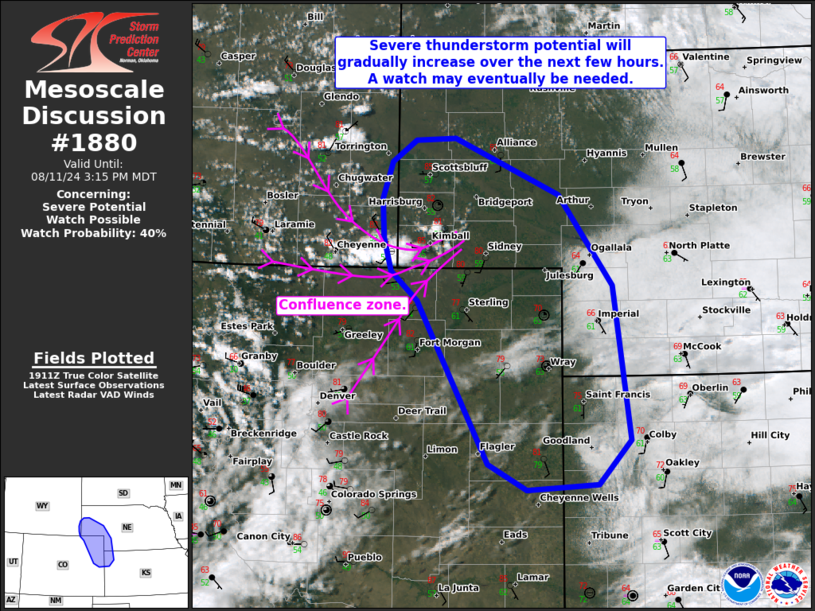
   Areas affected...Northeast CO...southwest NE...far southeast
   WY...and far northwest KS

   Concerning...Severe potential...Watch possible

   Valid 111917Z - 112115Z

   Probability of Watch Issuance...40 percent

   SUMMARY...The potential for a few severe thunderstorms capable of
   producing large hail and severe wind gusts will increase over the
   next few hours. A watch may eventually be needed for parts of the
   area.

   DISCUSSION...Boundary-layer cumulus is gradually deepening and
   expanding along an east/west-oriented confluence zone extending from
   southeastern WY into the southwestern NE Panhandle -- and isolated
   convective initiation is underway here. Additional attempts at
   development are ongoing along a lee trough extending northward
   across southwest WY. Given this focused mesoscale ascent and
   continued diurnal heating of a relatively moist boundary layer
   (middle/upper 50s to lower 60s dewpoints), current expectation is
   for a few thunderstorms to evolve/intensify during the next couple
   hours before spreading east-southeastward. The CYS VWP is sampling a
   unidirectional westerly shear profile (around 35 kt of 0-6 km
   shear), and this will continue increasing to around 40-50 kt with
   the approach of a midlevel jet. As a result, a few thunderstorms may
   intensify into organized clusters and/or supercell structures,
   posing a risk of large hail (generally up to 2 inches in diameter)
   and severe wind gusts to around 70 mph.

   Modest large-scale ascent and substantial MLCINH with eastward
   extent cast uncertainty on the overall coverage of the severe
   threat, though trends are being monitored for a possible watch this
   afternoon.

   ..Weinman/Hart.. 08/11/2024

   ...Please see www.spc.noaa.gov for graphic product...

   ATTN...WFO...LBF...GLD...BOU...CYS...

   LAT...LON   40690381 40960413 41270421 41630423 41970412 42180382
               42190335 41670208 40830143 39410123 39000162 38940247
               39190294 40240355 40690381
|
|
Top/All Mesoscale Discussions/Forecast Products/Home
|
|


