|
| Mesoscale Discussion 1879 |
|
< Previous MD Next MD >
|

|
   Mesoscale Discussion 1879
   NWS Storm Prediction Center Norman OK
   0124 PM CDT Sun Aug 11 2024

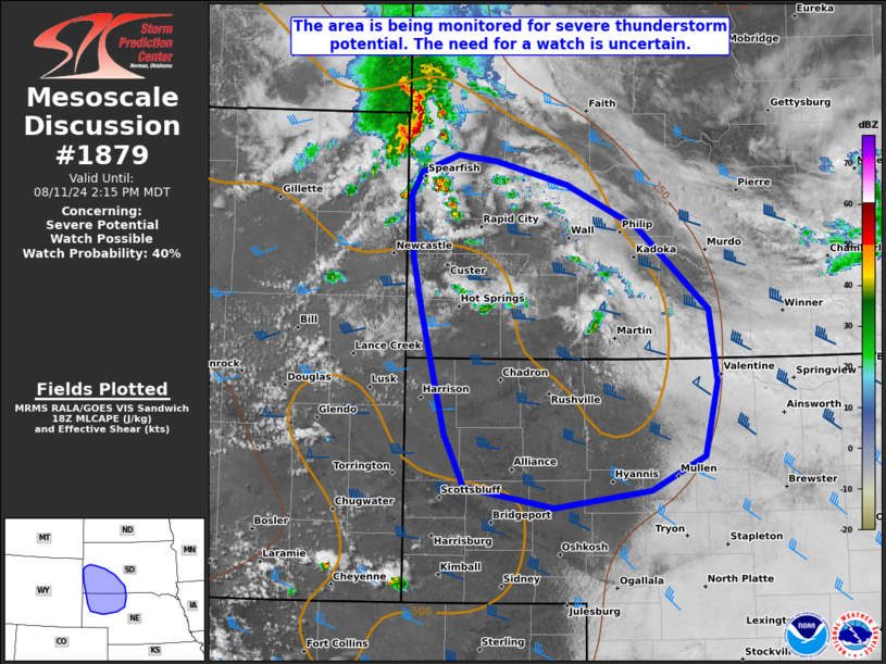
   Areas affected...Portions of southwestern SD and northwestern NE

   Concerning...Severe potential...Watch possible

   Valid 111824Z - 112015Z

   CORRECTED FOR GEOGRAPHIC DESCRIPTION

   Probability of Watch Issuance...40 percent

   SUMMARY...Portions of southwestern South Dakota into northwestern
   Nebraska are being monitored for a possible Severe Thunderstorm
   Watch.

   DISCUSSION...Isolated to widely scattered thunderstorms are evolving
   over far northeastern WY and over the Black Hills early this
   afternoon -- likely aided by ascent preceding a midlevel shortwave
   trough (and associated MCV) tracking eastward across southeastern
   MT, and heating over the higher terrain. Continue diurnal
   heating/destabilization amid middle/upper 50s to lower 60s dewpoints
   will continue to erode boundary-layer inhibition and contribute to
   500-1000 J/kg MLCAPE. This, coupled with long/mostly straight
   hodographs (around 40-45 kt of effective shear), will support a
   gradual increase in thunderstorm intensity/organization through the
   afternoon. The primary concern with any initial
   semi-discrete/splitting supercell structures is large hail
   (generally 1.5-1.75 inches) and locally severe gusts. Thunderstorms
   will generally track southeastward into northwestern Nebraska
   through the afternoon, where continued heating will support a
   corridor of sufficient (albeit weak) surface-based instability for a
   continued severe risk.

   There is uncertainty on the overall coverage of severe thunderstorms
   across the area, and the need for a watch is uncertain.

   ..Weinman/Hart.. 08/11/2024

   ...Please see www.spc.noaa.gov for graphic product...

   ATTN...WFO...LBF...UNR...CYS...

   LAT...LON   43810397 44330401 44510388 44650348 44600304 44410225
               44060146 43400067 42800059 42200073 41920133 41770240
               41950340 42380361 43370387 43810397
|
|
Top/All Mesoscale Discussions/Forecast Products/Home
|
|


