|
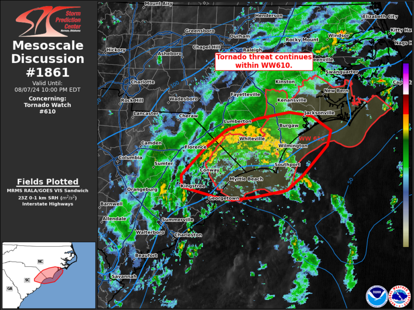
| Mesoscale Discussion 1861 |
|
< Previous MD Next MD >
|

|
   Mesoscale Discussion 1861
   NWS Storm Prediction Center Norman OK
   0656 PM CDT Wed Aug 07 2024

   Areas affected...coastal Carolinas

   Concerning...Tornado Watch 610...

   Valid 072356Z - 080200Z

   The severe weather threat for Tornado Watch 610 continues.

   SUMMARY...Tornado threat will continue within WW610.

   DISCUSSION...Recent radar across the coastal Carolinas has shown
   weak circulations off shore and within a band extending inland
   across southern North Carolina from Wilmington to the South Carolina
   border. Overall, the inland environment is characterized by weak
   thermodynamic profiles, given MLCAPE around 500-1000 J/kg and poor
   lapse rates (around 5 C/km). The most favorable low-level shear
   remains further inland, where around 150 m2/s2 0-1 km SRH is
   observed in objective analysis. Given the poor overlap of low-level
   shear with instability and generally weak lapse rates, a
   continuation of occasional weak circulations and potential for a
   tornado could not be ruled out in the short term.

   Further north across the northern portion of WW610 near the Outer
   Banks, warming has occurred with temperatures in the low to mid 80s
   yielding MLCAPE around 1500-2000 J/kg.  RAP forecast indicate that
   shear may increase across this region over the next several hours.
   Should a band of cells move into this region, there may be a more
   favorable corridor for tornadoes later in the watch period.

   ..Thornton.. 08/07/2024

   ...Please see www.spc.noaa.gov for graphic product...

   ATTN...WFO...MHX...RAH...ILM...

   LAT...LON   34257932 34537893 34727831 34827771 34757728 34517690
               34287696 33807745 33557776 33447838 33407881 33467916
               33617979 33797979 34257932
|
|
Top/All Mesoscale Discussions/Forecast Products/Home
|
|


