|
| Mesoscale Discussion 1860 |
|
< Previous MD Next MD >
|

|
   Mesoscale Discussion 1860
   NWS Storm Prediction Center Norman OK
   0630 PM CDT Wed Aug 07 2024

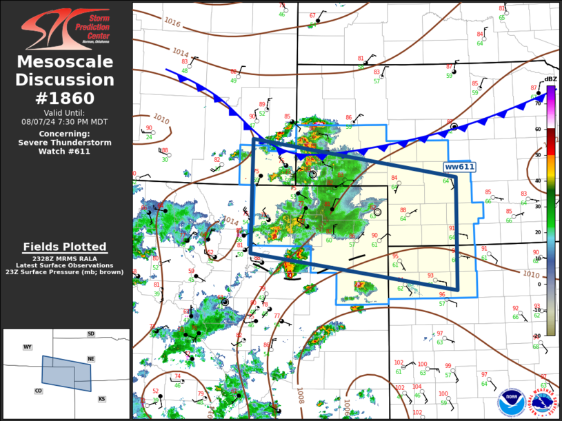
   Areas affected...Central High Plains

   Concerning...Severe Thunderstorm Watch 611...

   Valid 072330Z - 080130Z

   The severe weather threat for Severe Thunderstorm Watch 611
   continues.

   SUMMARY...Hail and wind threat will spread east with convection this
   evening.

   DISCUSSION...Water-vapor imagery suggests a weak disturbance may be
   encouraging upscale convective growth over the central High Plains
   early this evening. Upper anticyclone remains positioned over the
   Great Basin and northwesterly 500mb flow should strengthen a bit
   over northeast CO into western NE tonight. Scattered robust
   convection is gradually increasing in areal coverage as it
   propagates downstream into somewhat more buoyant airmass, especially
   along/south of the synoptic front that currently extends across the
   NE Panhandle into southeast WY. Prefrontal wind shift is also aiding
   convection across northeast CO and this activity should gradually
   advance toward northwest KS later this evening. Several supercells
   are noted within the larger convective complex, but mixed storm mode
   should linger for several hours before possible MCS evolves over
   northeast CO/southwest NE after sunset.

   ..Darrow.. 08/07/2024

   ...Please see www.spc.noaa.gov for graphic product...

   ATTN...WFO...LBF...GLD...BOU...CYS...

   LAT...LON   41760499 41120056 39250057 39870500 41760499
|
|
Top/All Mesoscale Discussions/Forecast Products/Home
|
|


