|
| Mesoscale Discussion 1859 |
|
< Previous MD Next MD >
|

|
   Mesoscale Discussion 1859
   NWS Storm Prediction Center Norman OK
   0157 PM CDT Wed Aug 07 2024

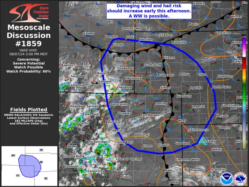
   Areas affected...portions of the central High Plains

   Concerning...Severe potential...Watch possible

   Valid 071857Z - 072100Z

   Probability of Watch Issuance...60 percent

   SUMMARY...Scattered strong to severe storms are expected early this
   afternoon across the higher terrain of eastern WY and CO. A mix of
   supercells and clusters may produce damaging winds and hail. A WW is
   being considered.

   DISCUSSION...As of 1845 UTC, regional visible and radar imagery
   showed initial thunderstorm development was ongoing over southern
   Laramie Range in eastern WY with additional storms developing over
   parts of northern CO. Further development and maturation of
   convection is expected over the next couple of hours as ascent from
   a subtle shortwave trough overspreads the central Rockies. Weak
   upslope flow and the approach of a cold front from the north will
   continue to advect seasonable low-level moisture (upper 50s to low
   60s F dewpoints) across the central High Plains. While currently
   MLCINH is still robust, continued heating, the approach of the front
   and upslope should gradually support destabilization with 1000-1500
   J/kg of MLCAPE expected. 35-40 kt of deep-layer shear will support
   storm organization with a mix of multi-cell clusters and supercells
   possible. Steep low and mid-level lapse rates will support strong
   downdrafts capable of damaging gusts, especially with any persistent
   clusters. Hail (some could be as large as 2 in) will also be
   possible, especially with any supercell structures.

   The initial ongoing storms are, so far, closely tied to the terrain
   where more persistent orographic ascent has removed most inhibition.
   As the capping over the plains is slowly removed these initial
   updrafts should move eastward across parts of northeast CO and
   eastern WY into western NE. CAM guidance varies on the timing of
   this transition, but observation trends suggest this could occur as
   early as the next hour or two. While confidence in the exact timing
   of the increasing severe risk is low, the potential for damaging
   wind gusts and hail suggest a watch may be needed.

   ..Lyons/Mosier.. 08/07/2024

   ...Please see www.spc.noaa.gov for graphic product...

   ATTN...WFO...LBF...GLD...BOU...CYS...

   LAT...LON   39170390 39470450 40010487 40610516 42020551 42720500
               42760479 42580250 42300186 41980135 41690110 41020064
               40490060 39390142 39120244 39080300 39170390
|
|
Top/All Mesoscale Discussions/Forecast Products/Home
|
|


