|
| Mesoscale Discussion 1858 |
|
< Previous MD Next MD >
|

|
   Mesoscale Discussion 1858
   NWS Storm Prediction Center Norman OK
   0117 PM CDT Wed Aug 07 2024

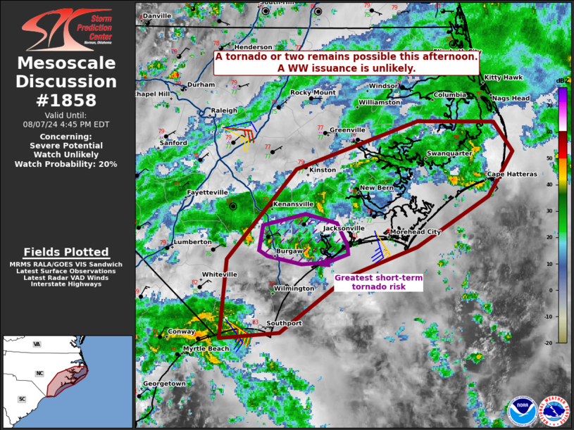
   Areas affected...portions of coastal North Carolina

   Concerning...Severe potential...Watch unlikely

   Valid 071817Z - 072045Z

   Probability of Watch Issuance...20 percent

   SUMMARY...A couple of tornadoes are possible this afternoon with the
   more organized storms embedded in the rainbands of Debby. The
   overall severe threat should remain isolated and a WW issuance is
   not anticipated.

   DISCUSSION...Modest surface heating has allowed for surface
   temperatures to warm to the 79-81 F mark about 50 miles inland from
   the coast. The LTX VAD profiler has recently shown over 300 m2/s2
   0-1 km SRH in the vicinity of where low-topped supercells are
   ongoing (southern NC coastline). As such, kinematics and current
   storm mode does favor tornado production. However, boundary-layer
   lapse rates remain poor (i.e. 5-5.5 C/km), so the instability needed
   for low-level vorticity stretching is marginal at best. As such, any
   tornadoes that manage to form should be brief and a WW issuance is
   not expected.

   ..Squitieri/Mosier.. 08/07/2024

   ...Please see www.spc.noaa.gov for graphic product...

   ATTN...WFO...MHX...RAH...ILM...

   LAT...LON   33837850 34527843 35307770 35737641 35727559 35467540
               35077566 34637642 34367715 33877786 33837850
|
|
Top/All Mesoscale Discussions/Forecast Products/Home
|
|


