|
| Mesoscale Discussion 1857 |
|
< Previous MD Next MD >
|

|
   Mesoscale Discussion 1857
   NWS Storm Prediction Center Norman OK
   1020 AM CDT Wed Aug 07 2024

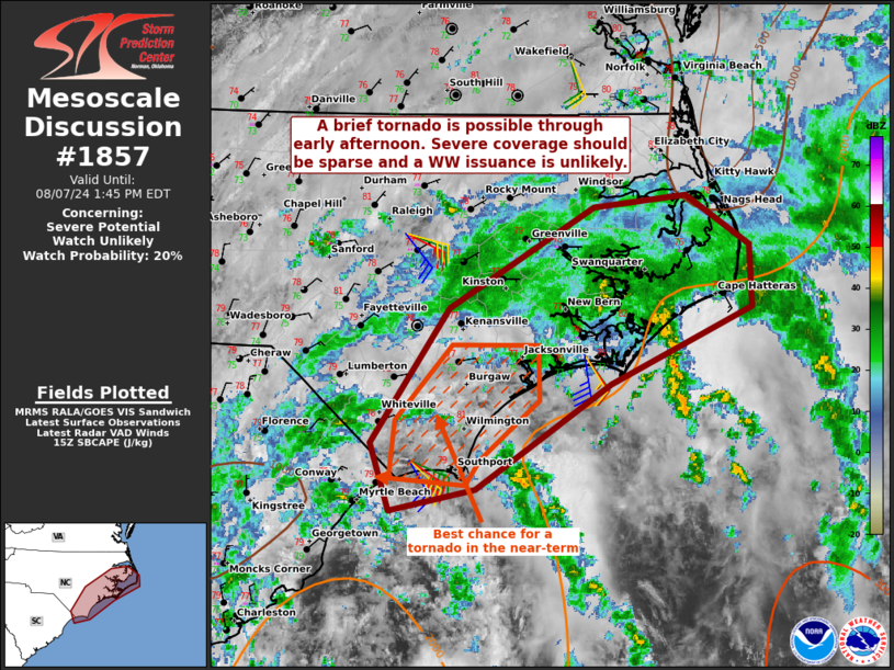
   Areas affected...portions of coastal North Carolina

   Concerning...Severe potential...Watch unlikely

   Valid 071520Z - 071745Z

   Probability of Watch Issuance...20 percent

   SUMMARY...A brief tornado cannot be ruled out through early
   afternoon. A WW issuance is not currently expected.

   DISCUSSION...Tropical Storm Debby continues to meander off of the
   coastline of the Carolinas as widespread rain/clouds from outer rain
   bands continue to overspread inland areas. Regional VADs
   (particularly LTX) depict sizable low-level hodographs and nearly
   300 m2/s2 0-1 km SRH. However, despite mid to upper 70s F
   contributing to over 1000 J/kg SB/MLCAPE, boundary-layer lapse rates
   remains quite poor (both the 12Z MHX observed sounding and 15Z
   mesoanalysis show 5 C/km in the 0-3 km layer). Given the favorable
   low-level shear, a brief tornado cannot be completely ruled out,
   especially over far southern NC, where some breaks in the clouds
   were noted. Nonetheless, overall tornado coverage is expected to be
   sparse, and a WW issuance is not currently anticipated.

   ..Squitieri/Mosier.. 08/07/2024

   ...Please see www.spc.noaa.gov for graphic product...

   ATTN...WFO...MHX...RAH...ILM...

   LAT...LON   33617860 34107878 35117808 35857677 35957595 35587538
               35117536 34557663 33767783 33617860
|
|
Top/All Mesoscale Discussions/Forecast Products/Home
|
|


