|
| Mesoscale Discussion 1850 |
|
< Previous MD Next MD >
|

|
   Mesoscale Discussion 1850
   NWS Storm Prediction Center Norman OK
   0531 PM CDT Tue Aug 06 2024

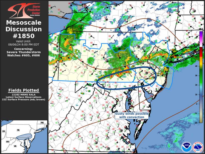
   Areas affected...Southeast PA...NJ...northern MD/DE

   Concerning...Severe Thunderstorm Watch 605...606...

   Valid 062231Z - 070000Z

   The severe weather threat for Severe Thunderstorm Watch 605, 606
   continues.

   SUMMARY...Gusty winds will accompany convection as it propagates
   east-southeast this evening. Some consideration is being given to a
   new WW into portions of northern MD/DE; however, ongoing convection
   may only clip adjacent regions just south of Severe Thunderstorm
   Watches 605/606.

   DISCUSSION...Considerable amount of convection has evolved along the
   southern portions of stronger westerly flow, immediately ahead of a
   progressive short-wave trough. Multiple clusters and several line
   segments extend across the OH Valley into eastern PA/northern NJ.
   One notable MCS is propagating across the southeast portions of
   ww605 into southwest ww606. Over the last hour or so the southern
   flank of this complex has gradually sagged to near the PA/MD border.
   It's very warm just south of this activity into northern MD where
   surface temperatures are holding in the 90s. There is some concern
   this MCS may propagate into northern MD/DE which is not currently in
   a Severe Thunderstorm Watch. Gusty winds should accompany these
   storms. Will continue to monitor for possible ww.

   ..Darrow.. 08/06/2024

   ...Please see www.spc.noaa.gov for graphic product...

   ATTN...WFO...PHI...CTP...LWX...

   LAT...LON   39827811 40397575 40227480 39627505 39397756 39827811
|
|
Top/All Mesoscale Discussions/Forecast Products/Home
|
|


