|
| Mesoscale Discussion 1849 |
|
< Previous MD Next MD >
|

|
   Mesoscale Discussion 1849
   NWS Storm Prediction Center Norman OK
   0344 PM CDT Tue Aug 06 2024

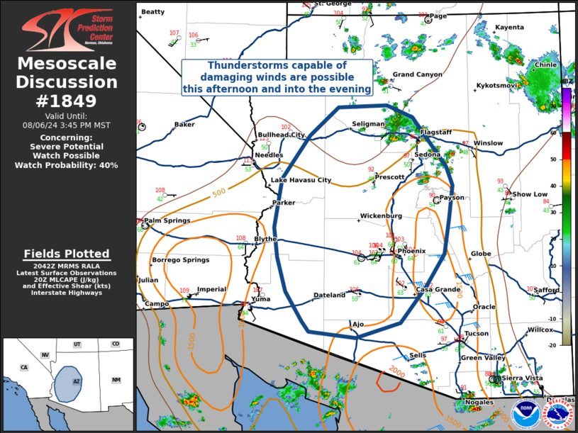
   Areas affected...Central and Southern Arizona

   Concerning...Severe potential...Watch possible

   Valid 062044Z - 062245Z

   Probability of Watch Issuance...40 percent

   SUMMARY...Some severe thunderstorms will be possible across central
   and southern Arizona this afternoon and evening, capable of
   primarily damaging straight-line winds. Watch issuance remains
   uncertain at this time, given uncertainty in future convective
   development and organization.

   DISCUSSION...Thunderstorms have developed over the Mogollon Rim in
   Arizona, where daytime heating has resulted in surface temperatures
   in the mid-to-upper 90s F at the top of the rim, and low-to-mid 100s
   F down in the lower desert. Deep inverted-v boundary-layer profiles
   and generally weak flow aloft will support damaging wind gusts from
   thunderstorm outflow.

   Current upper-air analyses and water vapor satellite trends suggest
   a belt of modest 20-25 kt easterly flow beginning to overspread
   central and southern Arizona, which could aid in convective
   organization and an increased severe threat. However, given
   convection has yet to move off of the Mogollon Rim, there is
   significant uncertainty in the magnitude of convective organization
   that can be expected.

   ..Halbert/Lyons/Hart.. 08/06/2024

   ...Please see www.spc.noaa.gov for graphic product...

   ATTN...WFO...TWC...FGZ...PSR...VEF...

   LAT...LON   34571408 35221360 35641309 35661222 35491175 35111146
               34761117 34471106 33991112 33471121 32981154 32461199
               32241278 32331359 32471371 32911401 33421416 33851421
               34571408
|
|
Top/All Mesoscale Discussions/Forecast Products/Home
|
|


