|
| Mesoscale Discussion 1842 |
|
< Previous MD Next MD >
|

|
   Mesoscale Discussion 1842
   NWS Storm Prediction Center Norman OK
   0959 AM CDT Tue Aug 06 2024

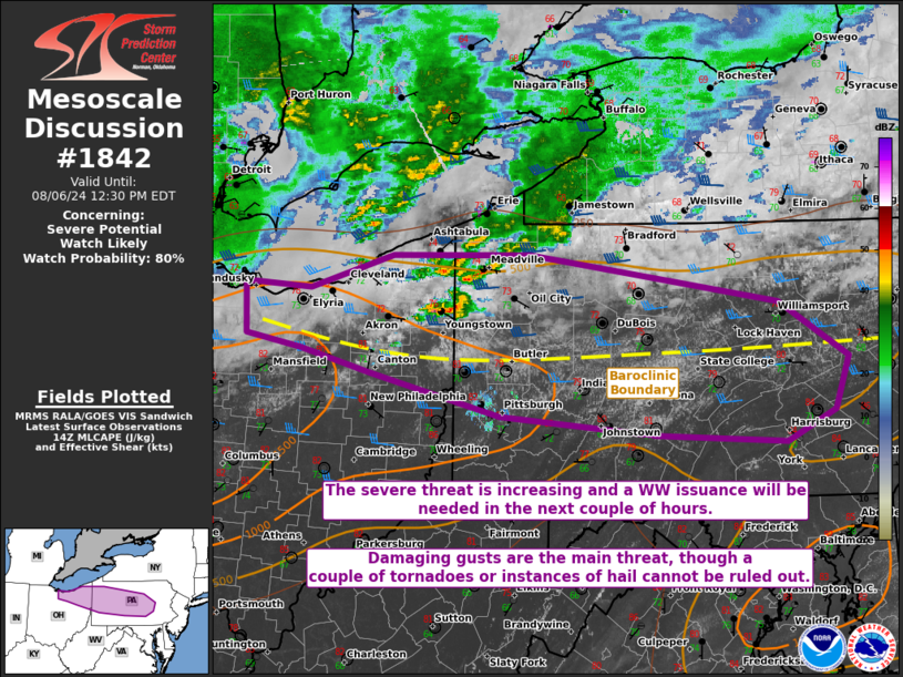
   Areas affected...portions of northeast Ohio into central
   Pennsylvania

   Concerning...Severe potential...Watch likely

   Valid 061459Z - 061630Z

   Probability of Watch Issuance...80 percent

   SUMMARY...The severe threat should increase through early afternoon.
   Multiple rounds of storms are possible, with damaging gusts as the
   main threat, though a couple of tornadoes are also possible. A WW
   issuance will eventually be needed.

   DISCUSSION...Multiple rounds of thunderstorms are percolating in
   intensity as they traverse a pronounced west-to-east oriented
   baroclinic boundary positioned from eastern OH into central PA. With
   continued surface heating and the approach of a 500 mb vort max over
   the Great Lakes, storms should continue to increase in coverage and
   intensity into early afternoon. 40+ kts of effective bulk shear,
   driven by strengthening 700-500 mb flow approaching from the west,
   will support organized updrafts amid 1500-2000 J/kg MLCAPE. More
   discrete storms could become supercellular, posing the threat for
   damaging gusts and perhaps a couple of tornadoes or instances of
   large hail. It is also possible that an MCS (perhaps even a bow
   echo) could develop over central PA later today, which could support
   a corridor of narrow but focused damaging gusts along the baroclinic
   boundary.

   A WW issuance will likely be needed in the next couple of hours to
   address the increasing severe threat.

   ..Squitieri/Hart.. 08/06/2024

   ...Please see www.spc.noaa.gov for graphic product...

   ATTN...WFO...PHI...CTP...PBZ...CLE...

   LAT...LON   41498280 41448208 41728118 41737968 41347696 40887620
               40437635 40177689 40247830 40398002 40748142 40948220
               41058278 41498280
|
|
Top/All Mesoscale Discussions/Forecast Products/Home
|
|


