|
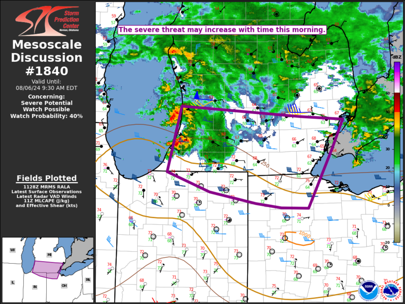
| Mesoscale Discussion 1840 |
|
< Previous MD Next MD >
|

|
   Mesoscale Discussion 1840
   NWS Storm Prediction Center Norman OK
   0631 AM CDT Tue Aug 06 2024

   Areas affected...Southern lower MI into extreme northern
   IN/northwest OH

   Concerning...Severe potential...Watch possible

   Valid 061131Z - 061330Z

   Probability of Watch Issuance...40 percent

   SUMMARY...The severe-thunderstorm threat may increase with time this
   morning.

   DISCUSSION...A long-lived storm cluster that produced a couple of
   small bowing segments earlier this morning has evolved into a pair
   of semi-discrete storms over southern Lake Michigan, with some
   midlevel rotation and supercell characteristics noted over the last
   30-60 minutes. Persistent low-level warm advection and ascent
   attendant to the convectively enhanced shortwave trough moving
   across the Great Lakes will support maintenance of these storms
   through the morning. MUCAPE of 500-1000 J/kg and favorable effective
   shear (generally greater than 40 kt) will continue to support
   organized storm structures.

   The ongoing storms are likely somewhat elevated, which renders the
   short-term severe threat uncertain. Locally damaging gusts could
   accompany these storms as they move into southwest lower MI, along
   with some nonzero hail potential. With favorable low-level shear/SRH
   in place, a brief tornado cannot be ruled out later this morning
   along the southern portion of the storm cluster, especially if any
   notable diurnal heating/destabilization can occur near an
   outflow-reinforced front. While the short-term threat may remain
   rather marginal and isolated, watch issuance will become possible if
   any uptick in storm organization and intensity is noted through mid
   morning.

   ..Dean/Edwards.. 08/06/2024

   ...Please see www.spc.noaa.gov for graphic product...

   ATTN...WFO...CLE...DTX...IWX...GRR...

   LAT...LON   42788621 42628367 42578277 42138300 41538333 41188353
               41198409 41268463 41448560 41758651 42788621
|
|
Top/All Mesoscale Discussions/Forecast Products/Home
|
|


