|
| Mesoscale Discussion 1839 |
|
< Previous MD Next MD >
|

|
   Mesoscale Discussion 1839
   NWS Storm Prediction Center Norman OK
   0341 AM CDT Tue Aug 06 2024

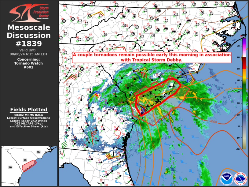
   Areas affected...coastal SC

   Concerning...Tornado Watch 602...

   Valid 060841Z - 061015Z

   The severe weather threat for Tornado Watch 602 continues.

   SUMMARY...A couple tornadoes remain possible early this morning in
   association with Tropical Storm Debby.

   DISCUSSION...To the northeast of the center of Tropical Storm Debby,
   small rotating cells have been noted early this morning within
   multiple bands of convection. A possible tornado was reported across
   Berkeley County, SC shortly before 07 UTC, within the outermost band
   of convection, with other briefly rotating cells noted within an
   inner band to the west/southwest of Charleston. The KCLX continues
   to indicate 0-1 km SRH of around 150-200 m2/s2, sufficient for at
   least transient low-level circulations.

   Weak instability will continue to be a limiting factor farther
   inland, but MLCAPE of around 500 J/kg will persist closer to the
   coast, where temperatures and dewpoints are in the mid/upper 70s F.
   Some tornado threat may gradually expand northeastward with time, in
   concert with Debby's slow forward motion.

   ..Dean.. 08/06/2024

   ...Please see www.spc.noaa.gov for graphic product...

   ATTN...WFO...ILM...CHS...

   LAT...LON   32498099 32948094 33647933 33607899 33347879 33037906
               32887937 32607980 32478009 32288037 32118072 32498099
|
|
Top/All Mesoscale Discussions/Forecast Products/Home
|
|


