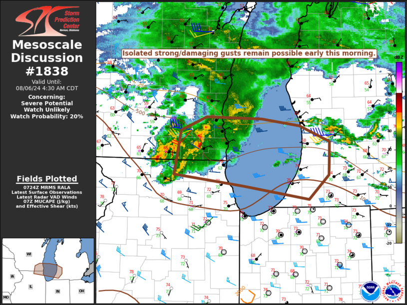
|
| Mesoscale Discussion 1838 |
|
< Previous MD Next MD >
|

|
   Mesoscale Discussion 1838
   NWS Storm Prediction Center Norman OK
   0226 AM CDT Tue Aug 06 2024

   Areas affected...Southeast WI...far northeast IL...southwest lower
   MI...southern Lake Michigan

   Concerning...Severe potential...Watch unlikely

   Valid 060726Z - 060930Z

   Probability of Watch Issuance...20 percent

   SUMMARY...Isolated strong/damaging gusts remain possible early this
   morning.

   DISCUSSION...A long-lived storm cluster is currently moving across
   southeast WI, with a recent history of localized wind gusts in the
   40-45 kt range. While this cluster has weakened somewhat as it has
   moved into a less unstable environment, a notable pressure
   perturbation persists, as noted by a relatively sharp pressure
   rise/fall couplet and earlier easterly 46 kt gust at KMSN.

   This cluster may persist overnight as it moves east-southeastward
   along a low-level baroclinic zone, aided by a rather strong
   nocturnal low-level jet. While substantial low-level stability will
   tend to limit a more widespread severe threat, isolated
   strong/damaging gusts remain possible early this morning, especially
   if the ongoing cluster can propagate into a somewhat more moist and
   unstable environment across southwest lower MI.

   ..Dean/Edwards.. 08/06/2024

   ...Please see www.spc.noaa.gov for graphic product...

   ATTN...WFO...IWX...GRR...LOT...MKX...

   LAT...LON   42268890 42968876 43178823 43138706 43028626 42778562
               42488564 42258564 41878607 42088743 42268890
|
|
Top/All Mesoscale Discussions/Forecast Products/Home
|
|


