|
| Mesoscale Discussion 1828 |
|
< Previous MD Next MD >
|

|
   Mesoscale Discussion 1828
   NWS Storm Prediction Center Norman OK
   0335 PM CDT Mon Aug 05 2024

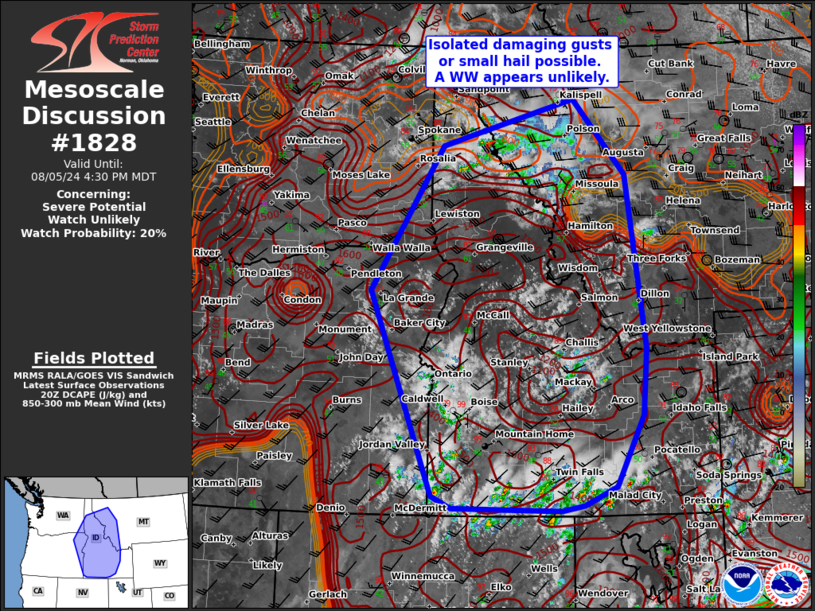
   Areas affected...portions of the northern Rockies and Northwest

   Concerning...Severe potential...Watch unlikely

   Valid 052035Z - 052230Z

   Probability of Watch Issuance...20 percent

   SUMMARY...Scattered thunderstorms may produce occasional damaging
   wind gusts and small hail. A WW is unlikely.

   DISCUSSION...As of 2030 UTC, afternoon vis/radar imagery showed
   thunderstorms beginning to develop across the higher terrain of the
   Northwest and northern Rockies. North of the prominent subtropical
   ridge, a weak Pacific trough was slowly overspreading the monsoon
   moisture over much of the Northwest. Weak buoyancy will continue to
   support thunderstorm development through much of the afternoon with
   occasional stronger updrafts. Modest westerly flow aloft may also
   support a few more organized multi-cell clusters or transient
   supercells. Steep low and mid-level lapse rates will promote a risk
   of locally damaging winds or small hail in the stronger cells this
   afternoon and evening. However, limited buoyancy and the lack of
   more focused forcing for ascent suggests the severe threat should
   remain fairly isolated. Conditions will continue to be monitored,
   but a WW currently appears unlikely.

   ..Lyons/Hart.. 08/05/2024

   ...Please see www.spc.noaa.gov for graphic product...

   ATTN...WFO...TFX...PIH...MSO...BOI...OTX...PDT...

   LAT...LON   42111654 42281695 42861719 45361828 47521678 47641638
               48231398 47101288 44501249 43501258 42421314 42141381
               42061428 42111654
|
|
Top/All Mesoscale Discussions/Forecast Products/Home
|
|


