|
| Mesoscale Discussion 1827 |
|
< Previous MD Next MD >
|

|
   Mesoscale Discussion 1827
   NWS Storm Prediction Center Norman OK
   0206 PM CDT Mon Aug 05 2024

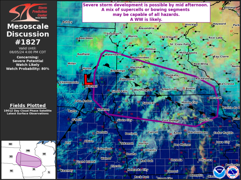
   Areas affected...portions of eastern South Dakota into southern
   Minnesota and northern Iowa

   Concerning...Severe potential...Watch likely

   Valid 051906Z - 052100Z

   Probability of Watch Issuance...80 percent

   SUMMARY...Scattered thunderstorms are expected to develop in the
   vicinity of a triple point move east/southeast across the upper
   Midwest. A mix of supercells and bowing segments may support a risk
   for all hazards. Confidence on the exact timing of storm development
   is low, but the severe risk will likely require a WW.

   DISCUSSION...Early afternoon WV imagery showed a well-defined
   shortwave trough embedded within expansive zonal/northwesterly flow
   over the northern third of the CONUS. Ahead of the shortwave trough,
   a weak wave cyclone along a quasi-stationary front has become better
   defined. Evident in visible imagery, subtle ascent from the
   approaching trough and low-level convergence/WAA along the front and
   ahead of the low is eroding early afternoon inhibition over parts of
   eastern SD and western MN. A warming and very moist air mass (70s F
   surface dewpoints) is supporting moderate to large buoyancy
   (2000-3000 J/kg of MUCAPE). Seasonably robust vertical shear is also
   in place ahead of the advancing trough with SPC mesoanalysis showing
   deep-layer values on the order of 45-50 kt. The favorable overlap of
   CAPE and shear will likely support organized storms with a mixed
   mode of supercells and bowing line segments.

   Initial storm development may occur as early as mid afternoon
   northwest of the surface low where low-level convergence is
   strongest and inhibition has rapidly weakened. Should this occur
   earlier in the day, as hinted by some CAM solutions, convection may
   initially be elevated with lingering surface inhibition. However,
   continued destabilization will likely support a transition to
   near-surface based with additional storm development likely through
   the remainder of the afternoon. Strong turning in the lowest few km
   near the quasi-stationary front, in combination with the supercell
   wind profiles, will likely support a risk for large hail. A couple
   of tornadoes are also possible with any well-developed supercells
   near the front. As storms evolve upscale along the boundary, a risk
   for damaging winds also appears likely.Given the increase in severe
   risk expected over the next few hours, a watch will likely be
   needed.

   ..Lyons/Hart.. 08/05/2024

   ...Please see www.spc.noaa.gov for graphic product...

   ATTN...WFO...DVN...ARX...MPX...DMX...FSD...ABR...

   LAT...LON   43779151 43209131 42679139 42339248 42779683 43319759
               44279757 44989724 45129704 45089664 44709498 44179246
               43779151
|
|
Top/All Mesoscale Discussions/Forecast Products/Home
|
|


