|
| Mesoscale Discussion 1818 |
|
< Previous MD Next MD >
|

|
   Mesoscale Discussion 1818
   NWS Storm Prediction Center Norman OK
   0605 PM CDT Sun Aug 04 2024

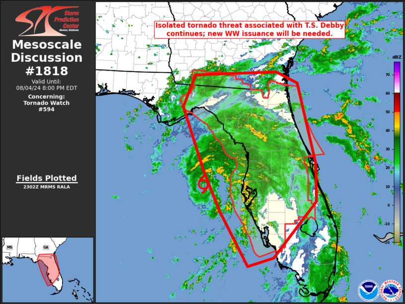
   Areas affected...much of central and northern Florida and into
   southern Georgia

   Concerning...Tornado Watch 594...

   Valid 042305Z - 050000Z

   The severe weather threat for Tornado Watch 594 continues.

   SUMMARY...Isolated/embedded rotating storms within T.S. Debby's
   convective bands will continue to pose a risk for brief tornadoes
   this evening and tonight.  A new Tornado Watch will be issued within
   the hour, given the scheduled 05/00 expiration of WW 594.

   DISCUSSION...Latest radar imagery shows the center of T.S. Debby to
   be located roughly 60 nautical miles west of KCLW (Clearwater, FL)
   at this time, and moving slowly northward.  Over the past couple of
   hours, a few cells within the convective bands surrounding Debby
   have exhibited rotation -- suggestive that some tornado risk
   persists at this hour.

   Tornado potential may increase slightly with time, as Debby likely
   strengthens to a category 1 Hurricane over the next several hours,
   per expectations laid out in the latest National Hurricane Center
   forecasts.  With Tornado Watch 594 set to expire at 05/00Z, a new
   tornado watch will be issued covering much of the same region,
   though not extending as far south as the current watch.

   ..Goss.. 08/04/2024

   ...Please see www.spc.noaa.gov for graphic product...

   ATTN...WFO...MFL...MLB...TBW...JAX...TAE...

   LAT...LON   27368349 28438397 30118462 30958427 31058178 30758115
               28628063 27608063 26148189 25928266 27368349
|
|
Top/All Mesoscale Discussions/Forecast Products/Home
|
|


