|
| Mesoscale Discussion 1817 |
|
< Previous MD Next MD >
|

|
   Mesoscale Discussion 1817
   NWS Storm Prediction Center Norman OK
   0507 PM CDT Sun Aug 04 2024

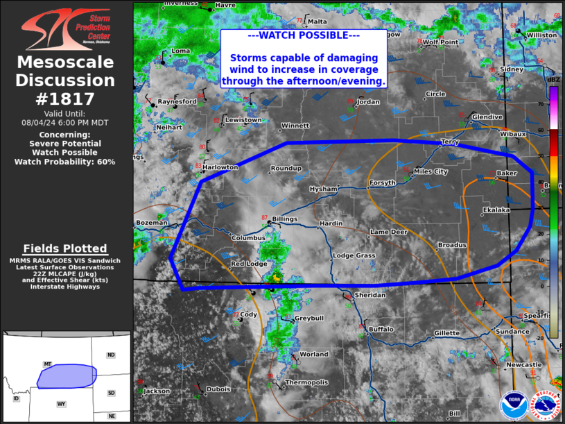
   Areas affected...central and eastern Montana...western Dakotas

   Concerning...Severe potential...Watch possible

   Valid 042207Z - 050000Z

   Probability of Watch Issuance...60 percent

   SUMMARY...Storms capable of damaging wind to increase through the
   afternoon/evening.

   DISCUSSION...A shortwave moving eastward across Montana this
   afternoon will provide forcing for ascent to erode MLCIN and result
   in thunderstorm development over the next few hours. Across
   central/eastern Montana, daytime heating has yielded MLCAPE around
   1000 J/kg. Surface objective analysis and forecast soundings also
   show profiles with steep low to mid-level lapse rates, deeply mixed
   profiles, and large dew point depressions which all favor downward
   momentum transfer. Deep layer shear 30-40 kts should provide
   organization for storms to grow upscale and present risk of damaging
   wind. A watch may be needed in the next couple of hours.

   ..Thornton/Smith.. 08/04/2024

   ...Please see www.spc.noaa.gov for graphic product...

   ATTN...WFO...BIS...UNR...BYZ...GGW...RIW...

   LAT...LON   45291035 46300982 46830821 46880619 46820505 46640392
               46410358 45940359 45710365 45400391 45220427 45050504
               45010572 44980656 44980762 44920981 44881010 45291035
|
|
Top/All Mesoscale Discussions/Forecast Products/Home
|
|


