|
| Mesoscale Discussion 1803 |
|
< Previous MD Next MD >
|

|
   Mesoscale Discussion 1803
   NWS Storm Prediction Center Norman OK
   0109 PM CDT Sat Aug 03 2024

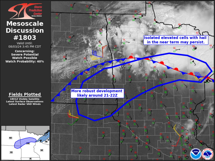
   Areas affected...northern Minnesota into eastern North Dakota and
   far northeast South Dakota

   Concerning...Severe potential...Watch possible

   Valid 031809Z - 032045Z

   Probability of Watch Issuance...40 percent

   SUMMARY...Isolated cells may produce hail at times over parts of
   northern Minnesota over the next couple hours. A greater risk of
   severe hail and wind will then materialize later this afternoon
   farther west with watch probability increasing.

   DISCUSSION...Scattered cells persist north of a quasi-stationary
   front across northern MN, as cooling aloft gradually sinks south.
   Most storms this morning have been short-lived but a longer-lived
   storms has developed with large hail reported. Given gradual warming
   south of this boundary and southwest winds just off the surface,
   these cells (though isolated) may persist as deep-layer shear is
   favorable, with hail potential.

   A greater risk of severe storms will likely develop by 21Z or so,
   farther west along the cold front and where instability will become
   stronger and surface based. Both large hail and damaging winds are
   expected to develop from far southeast ND and northeast SD into
   west-central MN, and a watch will likely be issued for that regime.

   ..Jewell.. 08/03/2024

   ...Please see www.spc.noaa.gov for graphic product...

   ATTN...WFO...DLH...FGF...ABR...BIS...

   LAT...LON   46759352 46579460 46319537 46039606 45559689 45379766
               45579842 46039858 46699826 47169722 47199692 47539518
               47669399 47589308 47319218 47019191 46669245 46759352
|
|
Top/All Mesoscale Discussions/Forecast Products/Home
|
|


