|
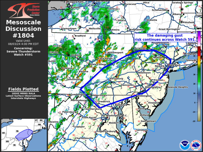
| Mesoscale Discussion 1804 |
|
< Previous MD Next MD >
|

|
   Mesoscale Discussion 1804
   NWS Storm Prediction Center Norman OK
   0153 PM CDT Sat Aug 03 2024

   Areas affected...portions of eastern Pennsylvania...the DelMarVA and
   into western New Jersey/southern New York.

   Concerning...Severe Thunderstorm Watch 591...

   Valid 031853Z - 032000Z

   The severe weather threat for Severe Thunderstorm Watch 591
   continues.

   SUMMARY...Gradual upscale growth into bands and clusters  is
   possible through this evening. Damaging gusts are likely across
   WW591.

   DISCUSSION...The severe risk continues with scattered storms ongoing
   across WW591 as of mid afternoon. Remaining inhibition has largely
   been negated and additional storm development/intensification should
   continue across much of the mid Atlantic. A few stronger cells have
   emerged over eastern PA and northern MD/VA over the last couple of
   hours. Early indications are that these storms may gradually evolve
   into more organized clusters or linear segments with time owing to
   the modest mid-level shear. Recent HRRR guidance also suggests
   continued intensification is possible this afternoon. Damaging gusts
   (some to as much as 60-70 mph) are possible with the strongest
   storms should they begin to consolidate. Additional storms may also
   develop through the day with at least an isolated severe risk
   possible with any longer-lived clusters.

   ..Lyons.. 08/03/2024

   ...Please see www.spc.noaa.gov for graphic product...

   ATTN...WFO...OKX...PHI...BGM...CTP...LWX...

   LAT...LON   39917825 40717717 41187605 41387536 41397467 41187410
               41037387 40857389 40607405 40187457 39837512 39457657
               39347695 39227731 39917825
|
|
Top/All Mesoscale Discussions/Forecast Products/Home
|
|


