|
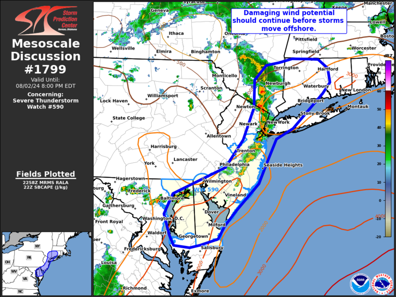
| Mesoscale Discussion 1799 |
|
< Previous MD Next MD >
|

|
   Mesoscale Discussion 1799
   NWS Storm Prediction Center Norman OK
   0601 PM CDT Fri Aug 02 2024

   Areas affected...portions of eastern maryland...Delaware...New
   Jersey and southern New York into Connecticut.

   Concerning...Severe Thunderstorm Watch 590...

   Valid 022301Z - 030000Z

   The severe weather threat for Severe Thunderstorm Watch 590
   continues.

   SUMMARY...The linear cluster of storms across the Mid Atlantic will
   remain capable of damaging gusts before moving offshore this
   evening. Additional storms over eastern MD and CT may also pose some
   risk for damaging winds through the evening.

   DISCUSSION...As of 23 UTC, regional radar imagery showed a line of
   storms stretching from far southern NY into parts of the DelMarVA.
   Periodic wind damage and a few severe gusts have been observed with
   this line of storms over the past couple of hours. Moderate buoyancy
   remains in place ahead of the line over the Atlantic Seaboard. While
   shear remains fairly minimal, a well-developed cold pool (forward
   speed of 20-25 mph) has allowed for continued propagation and
   support of transient strong updrafts. Damaging gusts will remain
   possible with the stronger cells along and ahead of the outflow
   before it moves offshore over the next hour.

   Farther north, the cold pool/storms may remain inland for more of
   the evening over parts of southern NY/Long Island and western CT.
   While temperatures are cooler than farther south, 70s F dewpoints
   and 1000-1500 J/kg of MLCAPE should remain sufficient for
   maintenance of the squall line as it approaches from the southwest.
   Isolated damaging gusts in the 45-60 mph range are possible as the
   northern half of the line and its cold pool approach. Storms should
   gradually weaken as the move farther east this evening and begin to
   encounter increasing nocturnal inhibition.

   Redevelopment along the southwestern flank of the initial line of
   storms over eastern MD may also support some severe risk through the
   evening hours over MD and DE. While confidence in storm organization
   here, moderate buoyancy should continue to support storm development
   with periodic stronger updrafts and water-loaded downdrafts capable
   of damaging near-severe gusts.

   ..Lyons.. 08/02/2024

   ...Please see www.spc.noaa.gov for graphic product...

   ATTN...WFO...BOX...OKX...ALY...PHI...AKQ...LWX...

   LAT...LON   39457628 39957498 40497455 41107428 41637425 41907395
               41957362 42027329 42027285 42017263 41837240 41567235
               41367253 40697330 40497371 40017397 39657415 39147471
               38847500 38587516 38467559 38417584 38467623 38637634
               38737638 39067649 39457628
|
|
Top/All Mesoscale Discussions/Forecast Products/Home
|
|


