|
| Mesoscale Discussion 1798 |
|
< Previous MD Next MD >
|

|
   Mesoscale Discussion 1798
   NWS Storm Prediction Center Norman OK
   0551 PM CDT Fri Aug 02 2024

   Areas affected...Eastern Mississippi...Central Alabama

   Concerning...Severe potential...Watch unlikely

   Valid 022251Z - 030115Z

   Probability of Watch Issuance...20 percent

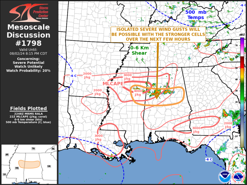
   SUMMARY...Isolated severe gusts will be possible over the next few
   hours with the stronger cells from eastern Mississippi eastward
   across central Alabama. The severe threat is expected to remain
   marginal, and WW issuance is unlikely.

   DISCUSSION...The latest mosaic radar imagery shows an east-to-west
   oriented broken line of strong to locally severe thunderstorms
   extending from just north of Birmingham westward into eastern
   Mississippi. This line is located from near and just to the south of
   an axis of strong instability, where the RAP is estimated MLCAPE in
   the 3000 to 4500 J/kg range. In addition to the strong instability,
   the latest WSR-88D VWP at Birmingham has 0-6 km shear in the 20 to
   25 kt range. This will support an isolated wind-damage threat as the
   cluster moves southeastward across far eastern Mississippi and
   central Alabama this evening. If the line can continue to organize a
   cold pool, then the potential for severe wind gusts could continue
   for a few more hours.

   ..Broyles/Smith.. 08/02/2024

   ...Please see www.spc.noaa.gov for graphic product...

   ATTN...WFO...BMX...MEG...JAN...

   LAT...LON   33708816 33848882 33838923 33638945 33268940 32958924
               32748898 32618829 32618698 32718602 32918559 33208548
               33568549 33748581 33638684 33708816
|
|
Top/All Mesoscale Discussions/Forecast Products/Home
|
|


