|
| Mesoscale Discussion 1795 |
|
< Previous MD Next MD >
|
|
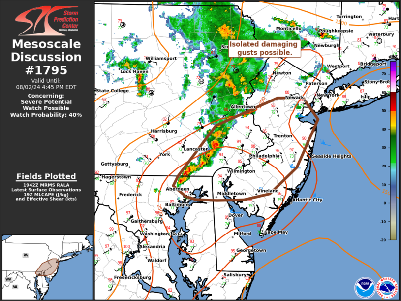
   Mesoscale Discussion 1795
   NWS Storm Prediction Center Norman OK
   0245 PM CDT Fri Aug 02 2024

   Areas affected...parts of the Mid Atlantic

   Concerning...Severe potential...Watch possible

   Valid 021945Z - 022045Z

   Probability of Watch Issuance...40 percent

   SUMMARY...An intensifying cluster of thunderstorms over northeast MD
   and eastern PA may pose a risk for isolated damaging gusts this
   afternoon. A WW is uncertain though convective trends will continue
   to be monitored.

   DISCUSSION...As of 1940 UTC, regional radar imagery showed scattered
   thunderstorms ongoing over parts of the Mid Atlantic. Over the last
   hour, a cluster near the MD/PA border has slowly intensified with a
   notable increase in lightning and reflectively. Likely supported by
   subtle ascent from a passing shortwave and remnant convective
   outflows, 1500-2500 J/kg of MLCAPE will likely continue to support
   strong updraft development/maintenance. Vertical shear is quite
   limited with flow generally less than 25 kt. Storm intensity will
   likely remain tied to forward propagation along advancing outflow
   with this cluster. The moderate buoyancy and large water loading
   will likely support a isolated stronger downdrafts with low-end
   potential for 50-60 mph gusts. Storms should track east/northeast
   through the afternoon across parts of eastern PA into NJ. Storm
   organization appears quite limited.

   ..Lyons/Hart.. 08/02/2024

   ...Please see www.spc.noaa.gov for graphic product...

   ATTN...WFO...OKX...PHI...CTP...LWX...

   LAT...LON   40407573 40777465 40767419 40477393 39847432 39497479
               39417523 39397569 39417606 39447623 39597646 39717638
               40407573
|
|
Top/All Mesoscale Discussions/Forecast Products/Home
|
|


 @NWSSPC