|
| Mesoscale Discussion 1794 |
|
< Previous MD Next MD >
|

|
   Mesoscale Discussion 1794
   NWS Storm Prediction Center Norman OK
   1243 PM CDT Fri Aug 02 2024

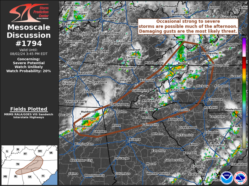
   Areas affected...portions of the Southeast and southern Appalachians

   Concerning...Severe potential...Watch unlikely

   Valid 021743Z - 021945Z

   Probability of Watch Issuance...20 percent

   SUMMARY...Scattered strong to occasional severe storms evolving
   along previous outflow may pose a risk for isolated damaging gusts
   this afternoon. Confidence in storm organization is low, and a WW is
   not expected.

   DISCUSSION...As of 1740 UTC, regional radar and visible imagery
   showed several clusters of strong to occasional severe thunderstorms
   evolving across parts of the Southeast and southern Appalachians.
   Over the past 2 hours, these storms have intensified along previous
   outflow boundaries across northern AL and a weak MCV over TN/VA/NC
   from prior convection. Weak ascent ahead of a broad central US
   trough should continue to support additional storm development
   through this afternoon. Robust diurnal heating and dewpoints in the
   70s F are supporting 1500-2000 J/kg of MLCAPE. Vertical shear is not
   particularly robust, generally less than 20 kt. However, some slight
   mid-level enhancement has been noted on area VADs ahead of the MCV
   across western NC and VA. Given the moderate buoyancy but limited
   deep-layer shear, storm organization should be confined to stronger
   pulse-type updrafts with microburst potential. Isolated strong to
   occasionally severe gusts are possible with the more robust cores
   through this afternoon. However, given the limited potential for
   storm organization, confidence in the need for a WW is low.

   ..Lyons/Hart.. 08/02/2024

   ...Please see www.spc.noaa.gov for graphic product...

   ATTN...WFO...RNK...RLX...GSP...MRX...FFC...BMX...HUN...

   LAT...LON   34898172 34498319 34258420 33898580 33948655 34128683
               34388683 34808613 35178503 36458296 37468185 37358112
               36648051 35968066 35128127 34898172
|
|
Top/All Mesoscale Discussions/Forecast Products/Home
|
|


