|
| Mesoscale Discussion 1788 |
|
< Previous MD Next MD >
|

|
   Mesoscale Discussion 1788
   NWS Storm Prediction Center Norman OK
   0219 PM CDT Thu Aug 01 2024

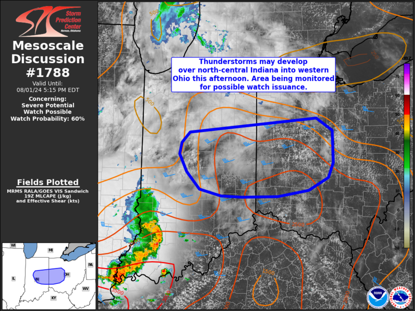
   Areas affected...portions of northern/central Indiana into western
   Ohio

   Concerning...Severe potential...Watch possible

   Valid 011919Z - 012115Z

   Probability of Watch Issuance...60 percent

   SUMMARY...Thunderstorms are expected to develop across
   northern/central Indiana into western Ohio over the next couple of
   hours. These storms will have potential to produce isolated damaging
   gusts around 50-65 mph and sporadic hail to near 1 inch diameter.
   Timing and coverage of severe risk is uncertain, but this area is
   being monitored for possible watch issuance within the next couple
   of hours.

   DISCUSSION...Latest visible satellite imagery shows deepening
   cumulus within a broader area of mid/high cloudiness across
   northern/central Indiana. More extensive cumulus development is
   noted further downstream across western Ohio where clearer skies
   have persisted. Heating into the mid/upper 80s F amid 70s F
   dewpoints is supporting moderate instability (1500-2500 J/kg).
   Midlevel inhibition has also mostly been eroded as a convectively
   enhanced vorticity max impinges on the region. Continued
   heating/destabilization should support thunderstorm development
   within the next hour or two.

   Vertical shear is somewhat modest, with around 25-35 kt effective
   shear magnitudes noted in regional VWP data and in
   mesoanalysis/point forecast soundings. This should be sufficient for
   organized cells/clusters. Steepening low-level lapse rates amid a
   favorable combination of instability and shear will foster damaging
   wind potential. Midlevel lapse rates will remain modest, but a few
   more intense updrafts may be capable of marginally severe hail as
   well.

   ..Leitman/Bunting.. 08/01/2024

   ...Please see www.spc.noaa.gov for graphic product...

   ATTN...WFO...CLE...ILN...IWX...IND...

   LAT...LON   39408563 39538614 39858645 40178663 40388657 40568638
               40828337 40598298 40018298 39748310 39518357 39408429
               39388514 39408563
|
|
Top/All Mesoscale Discussions/Forecast Products/Home
|
|


