|
| Mesoscale Discussion 1787 |
|
< Previous MD Next MD >
|

|
   Mesoscale Discussion 1787
   NWS Storm Prediction Center Norman OK
   0206 PM CDT Thu Aug 01 2024

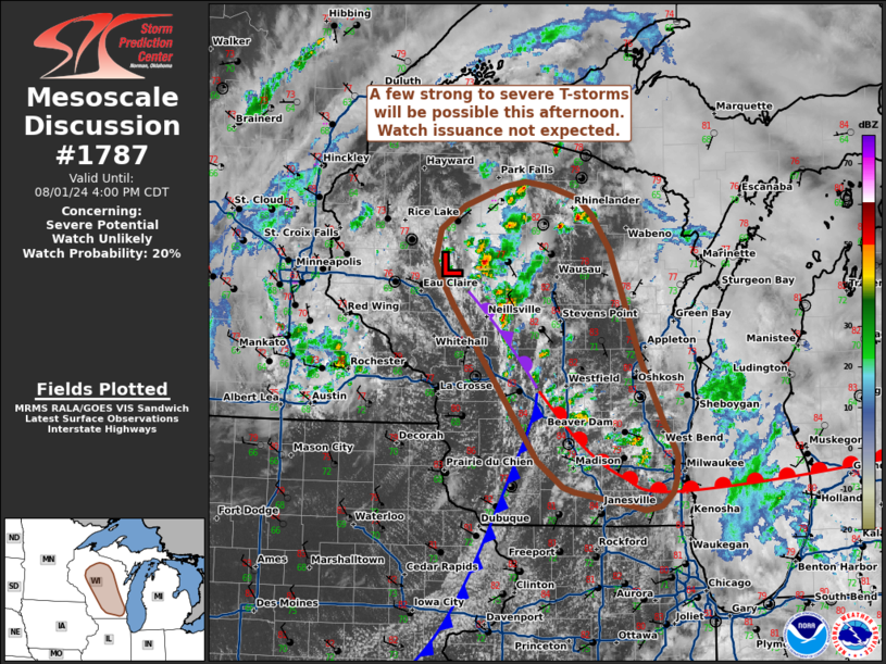
   Areas affected...Wisconsin

   Concerning...Severe potential...Watch unlikely

   Valid 011906Z - 012100Z

   Probability of Watch Issuance...20 percent

   SUMMARY...Thunderstorm coverage is expected to increase as
   destabilization in the vicinity of a weak surface low continues.
   More intense storms may be capable of severe wind, hail, and perhaps
   a short-lived tornado.

   DISCUSSION...Convection has been ongoing for much of the late
   morning and early afternoon hours across central WI in the vicinity
   of a weak surface low. Gradual cloud-top cooling has been noted over
   the past 30-60 minutes in GOES IR imagery, implying that convection
   is slowly becoming more intense amid continued daytime heating and
   gradually cooling mid-level temperatures. Thunderstorm activity is
   expected to increase along the surface fronts draped to the
   south/southeast of the low. Initially discrete cells quickly
   developing into clusters given the weak (20-25 knots) deep-layer
   wind shear noted in regional VWPs. More intense updraft pulses may
   be capable of large hail (generally between 0.75 to 1.25 inches),
   and perhaps a brief landspout tornado given ambient low-level
   vorticity in place along the surface boundaries and adequate
   low-level buoyancy. As convection grows upscale, damaging winds
   should become the predominant hazard. Limited wind shear magnitudes
   and a high probability for destructive storm interactions should
   modulate the overall severe threat. Watch issuance is not
   anticipated.

   ..Moore/Bunting.. 08/01/2024

   ...Please see www.spc.noaa.gov for graphic product...

   ATTN...WFO...GRB...MKX...DLH...ARX...MPX...

   LAT...LON   45419122 45649088 45849035 45899006 45848971 45738934
               45568913 45228888 44148848 43518817 43178798 42948799
               42818804 42698820 42658842 42708863 42828937 42888953
               43148988 44669103 44949123 45119130 45419122
|
|
Top/All Mesoscale Discussions/Forecast Products/Home
|
|


