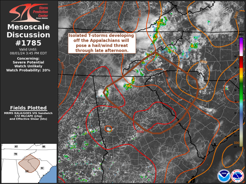
|
| Mesoscale Discussion 1785 |
|
< Previous MD Next MD >
|

|
   Mesoscale Discussion 1785
   NWS Storm Prediction Center Norman OK
   1240 PM CDT Thu Aug 01 2024

   Areas affected...Northern Georgia into the western Carolinas

   Concerning...Severe potential...Watch unlikely

   Valid 011740Z - 011945Z

   Probability of Watch Issuance...20 percent

   SUMMARY...Isolated to scattered T-storms will pose a damaging wind
   and large hail threat through the coming hours. Watch issuance is
   not expected given an overall modest kinematic environment.

   DISCUSSION...Thunderstorm initiation is underway within the southern
   Appalachians from northern GA into the western Carolinas. Recent
   surface observations show temperatures reaching into the upper 80s
   and low 90s, which should be the convective temperature for most
   surface-based parcels across the region. This also implies that any
   lingering nocturnal inhibition is quickly being removed - as evident
   by an expanding shallow cumulus field. Consequently, thunderstorm
   development appears possible in the short term as heating of the
   higher terrain continues. Additionally, an uptick in convective
   intensity is anticipated in the coming hours as MLCAPE increases to
   around 3500 J/kg by peak heating. The upstream KMRX VWP sampled
   20-25 knot winds above roughly 5 km, which should support some
   degree of storm organization and longevity. The combination of
   meager, but sufficient, deep-layer shear, strong buoyancy, and
   steepening low-level lapse rates should support semi-organized
   discrete cells and clusters with an attendant risk for large hail
   (most likely 0.75 to 1.25 inches) and 50-60 mph downburst winds.
   Despite the favorable thermodynamic environment, weak/localized
   orographic ascent and the modest kinematic environment should
   modulate overall storm coverage and intensity.

   ..Moore/Gleason.. 08/01/2024

   ...Please see www.spc.noaa.gov for graphic product...

   ATTN...WFO...CAE...GSP...MRX...FFC...

   LAT...LON   32958268 32958299 33098336 34168495 34398512 34598501
               34918440 35628338 35878290 34858111 34488105 34238113
               33488174 33138226 32958268
|
|
Top/All Mesoscale Discussions/Forecast Products/Home
|
|


