|
| Mesoscale Discussion 1784 |
|
< Previous MD Next MD >
|

|
   Mesoscale Discussion 1784
   NWS Storm Prediction Center Norman OK
   1113 AM CDT Thu Aug 01 2024

   Areas affected...portions of southern IL...southern IN...and
   western/central Kentucky

   Concerning...Severe potential...Watch likely

   Valid 011613Z - 011745Z

   Probability of Watch Issuance...80 percent

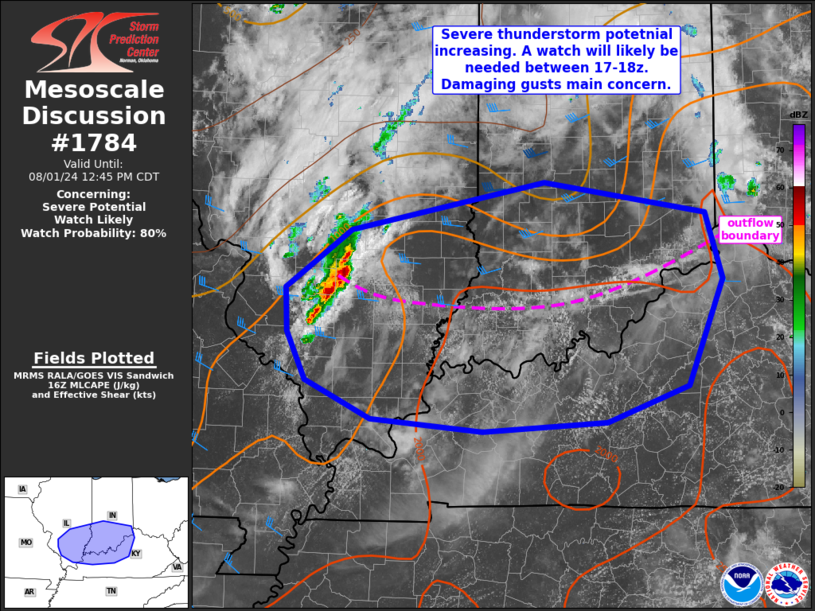
   SUMMARY...Thunderstorms coverage and intensity is expected to
   increase over the next couple of hours across southern Illinois and
   Indiana into parts of western/central Kentucky. Damaging gusts will
   be the main concern with activity through the afternoon. A watch
   will likely be needed between 17-18z.

   DISCUSSION...Thunderstorms are increasing late this morning in the
   vicinity of an MCV over southern IL. Visible satellite and surface
   obs show an outflow boundary oriented west to east across southern
   IL into southern IN ahead of this MCV and developing convection.
   Strong heating is already occurring across the downstream airmass,
   with temperatures already in the mid/upper 80s along/south of the
   outflow. With dewpoints in the 70s, the airmass is quickly
   destabilizing and low/midlevel inhibition rapidly eroding. This
   should aid in gradually increasing convection (both in coverage and
   intensity) over the next couple of hours.

   West/southwesterly, mostly unidirectional wind profiles, with flow
   around 30-40 kt in the midlevels, will support eastward developing
   storms tracking along the outflow and instability gradient. Upscale
   development into a forward propagating MCS is expected, with
   damaging gusts being the main concern through the afternoon. While
   flow is mostly unidirectional, some enhancement to SRH is possible
   in the vicinity of the outflow boundary. Low-level instability is
   quite high given the very moist airmass. If a well developed bow
   materializes, a tornado or two can not be ruled out via transient
   line-embedded mesovortex features, though damaging winds will be the
   primary hazard. A severe thunderstorm watch will likely be needed in
   the next hour or two.

   ..Leitman/Gleason.. 08/01/2024

   ...Please see www.spc.noaa.gov for graphic product...

   ATTN...WFO...ILN...LMK...IND...PAH...ILX...LSX...

   LAT...LON   39088896 39528677 39248494 38648474 37698515 37378607
               37298746 37418872 37758946 38188967 38568969 39088896
|
|
Top/All Mesoscale Discussions/Forecast Products/Home
|
|


