|
| Mesoscale Discussion 1775 |
|
< Previous MD Next MD >
|

|
   Mesoscale Discussion 1775
   NWS Storm Prediction Center Norman OK
   0604 PM CDT Wed Jul 31 2024

   Areas affected...Parts of southeastern NE and southwestern IA

   Concerning...Severe Thunderstorm Watch 582...

   Valid 312304Z - 010000Z

   The severe weather threat for Severe Thunderstorm Watch 582
   continues.

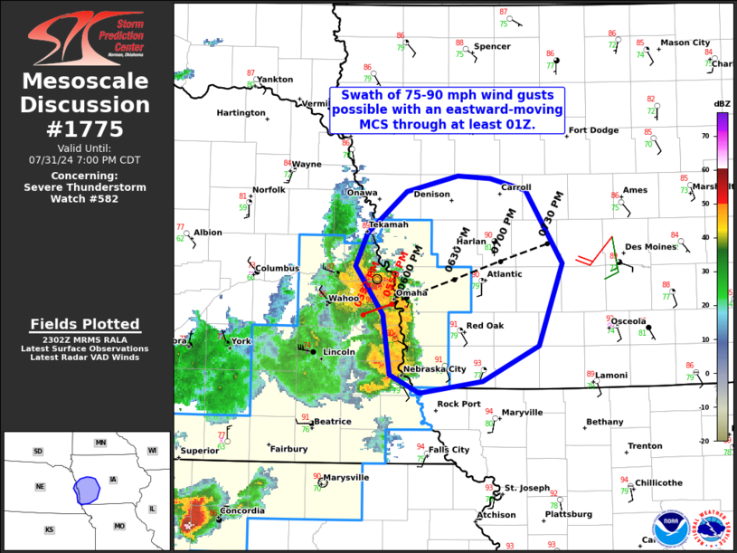
   SUMMARY...A swath of 75-90 mph wind gusts is possible with an MCS
   moving eastward across southeastern Nebraska into southwestern IA
   through at least 01Z.

   DISCUSSION...As of 2250Z, radar data from KOAX indicates a
   well-organized, forward-propagating MCS tracking east-northeastward
   across southeastern NE into southwestern IA at around 45 kt. This
   MCS has a well-established rear-inflow jet and northern book-end
   vortex. Wind gusts upwards of 80-90 mph have been reported with the
   MCS in southeastern NE. Downstream, extreme surface-based
   instability (4000-4500 J/kg MLCAPE) and around 40 kt of deep-layer
   shear (per VWP data) oriented perpendicular the gust front should
   support the maintenance of this MCS across southeastern IA through
   at least 01Z. Wind gusts of 75-90 mph are the main concern, and
   brief mesovortex tornadoes will also remain possible.

   ..Weinman.. 07/31/2024

   ...Please see www.spc.noaa.gov for graphic product...

   ATTN...WFO...DMX...EAX...OAX...

   LAT...LON   41149604 41509632 41759621 42089581 42199529 42189496
               42099459 41539423 40909446 40639503 40539567 40689597
               41149604
|
|
Top/All Mesoscale Discussions/Forecast Products/Home
|
|


